Back to Search
Property profile & analytics
OFF-MARKET
Specialty properties
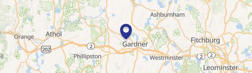
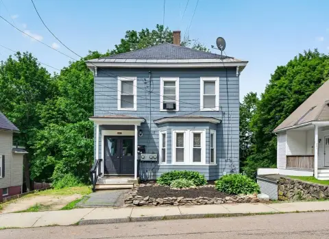
291 Chestnut St Gardner, MA 01440-2705
Individually Owned
7-yr Hold
Free & Clear
Property ID
US38-0089980
Property profile
Verified
Property type
Specialty properties
Use group
CHARITABLE ORGANIZATION
Year built
1870
Total area
2,312 SF
Lot
0.32 ac (13,728 SF)
APN
GARD M:R22 B:13 L:34
UPID
US38-0089980
Cap rate & NOI
Priority signal for investors
Implied cap rate, NOI & suggested price
Cap rate vs submarket · NOI estimate · 3 price anchors
Implied cap rate, NOI & suggested price
Cap vs submarket · NOI estimate · 3 price anchors
Current use
Occupant on record · Public records
-
Bridge of Central Mass Inc Social Service Agency Charitable Organization
Value estimations
Realmo proprietary · 4 methods
AI Approach
AI
by Request
CAP Approach
CAP
by Request
Comparable Approach
Comparable
by Request
Blend (final)
Blend
by Request
Owner & transaction history
For Justice Comnty Resrcs · 7 yrs held
For Justice Comnty Resrcs
since 2019
7 recorded transactions
Zoning & alternative use
Permitted uses
Permitted uses
Allowed · conditional · prohibited
Cap rate
Implied · in-place · derived from last sale + estimated NOI
Implied Cap rate
#1
Implied · in-place · NOI ÷ last sale
In-place · derived from last sale + estimated NOI
Cap rate, NOI & submarket benchmark
Implied cap rate vs Gardner submarket · NOI estimate · Typical band, median & reading
Implied cap rate, NOI & submarket benchmark
Cap vs Gardner submarket · NOI estimate · typical band, median & reading
Refine your cap rate
8-question underwriting flow
1.
Property current status — Going-In vs Stabilized
2.
Price for denominator — asking / offer / market
3.
Leasing status & lease structure (NNN / Gross)
4.
Tenant risk profile & vacancy assumption
5.
Upload T12 / rent roll / OM (optional)
Refine in 60 seconds, get exact suggested price
T12 upload · Submarket benchmarks · Sensitivity grid
Suggested price · 3 cap rate anchors
Income approach @ 5% / 7% / 9% — aggressive / typical / conservative
Suggested price at 5% / 7% / 9% cap
Aggressive / typical / conservative · Implied $/SF per anchor · Sensitivity grid
Suggested price at 5% / 7% / 9% cap
Aggressive / typical / conservative · implied $/SF · sensitivity
Value
AI, CAP & Alternative Use estimations · Realmo proprietary blendValue Estimations
Based on Realmo’s proprietary methodology
AI Approach
CAP Approach
Comparable Approach
Alternative Use
Get a detailed, property-specific estimation — fast and free
Price per SF
Sale + rent benchmarks
Subject property
—
Submarket sale & rent benchmarks
Median sale $/SF · Asking & closed rent · Submarket vacancy
Submarket sale & rent benchmarks
Median sale $/SF · asking & closed rent · submarket vacancy
Property tax & assessments
Tax year 2024Property tax & assessments
Tax year 2024
Assessed value
$381,500
Assessed 2024
Previous assessed
$381,500
+0.0% YoY
Assessed land
$64,400
Assessed improvement
$317,100
Comparables
6 recent transactions · within 1.5 miComparable in this city
6 recent transactions
Comparable in this City


Similar Nearby for Sale


Similar Nearby for Lease


Recent comparable sales
Sale price & price/SF · Sale date & distance · Adjustments & confidence
Recent comparable sales
Sale price & $/SF · sale date & distance · adjustments
Property description
Physical attributes from public recordsBuilding & lot
Public records
Property type
Specialty properties
Use group
CHARITABLE ORGANIZATION
Status
Off-Market
Year built
1870
Heating
STEAM
Buildings
1
Stories
2
Units
1
Rooms
10
Bathrooms
3
Total area
2,312 SF
Lot
0.32 ac (13,728 SF)
APN
GARD M:R22 B:13 L:34
UPID
US38-0089980
Jurisdiction
GARDNER
Zoning & alternative use
Zoning · permitted uses
Permitted & conditional uses
Allowed uses · Special-permit conditions · Prohibited uses
Permitted & conditional uses
Allowed · special-permit conditions · prohibited
Building & site characteristics
From public records
Year built
1870
Heating
STEAM
Stories
2
Buildings
1
Units
1
Rooms
10
Bathrooms
3
Lot
0.32 ac
Current owner
From public records · entity-resolved
For Justice Comnty Resrcs
Individual
Free & Clear · 7 yrs held
Mailing address
355 BOYLSTON ST, BOSTON, MA 02116-3332
Ownership since
2019
Owner contacts — direct phone, email, and related entities
Decision-maker phone · Verified email · Related entities & filings
Owner contacts
Email · phone · related entities
Sales History
7 recorded events · public records
Date
Price
Buyer
Seller
Deed Type
Mortgage
Jun 28, 2019
$218,500
For Justice Comnty Resrcs
Ctrl,bridge & Mass
Quit Claim Deed
—
Dec 29, 2010
—
Bridge Of Central Ma INC
—
Deed Of Trust
related
$500,000 · Peoples Bank
Jun 10, 2009
$203,162
Bridge Of Central Ma INC
Gaston,ralph
Grant Deed
$198,162 · Lorraine Gaston
Nov 30, 1999
$134,000
Ralph Gaston
Crossman,austin G
Grant Deed
—
Oct 5, 1999
—
Austin G Crossman
—
Deed Of Trust
related
$80,000 · Fidelity Cp Bank
May 29, 1996
—
Austin G Crossman
—
Deed Of Trust
related
$40,000 · Fidelity Cp Bank
Mar 19, 1987
—
Ann F Crossman
—
Deed Of Trust
related
$25,000 · Fidelity Cp Bank
Coming soon
Costs & Benchmarks
Operating expenses, capex projections, utility benchmarks, and submarket comparables — all in one view.
Coming soon
Risks
Flood, climate, environmental, title, and tenant-concentration risk — surfaced with mitigations and source citations.
Try Rey
Ask anything about this address in plain English.
“Is 15.6% cap rate sustainable?” · “Best tenant mix for BU1?” · “What’s the redev upside?”
You own 291 Chestnut St?
List it free. Reach 20,000 daily buyers.
We’ve already pulled the facts. Confirm photos + price and you’re live in 2 minutes.
List this address →
Full reports are paid
Unlock the full Property Analytics report
Start free for 7 days — no card required. Full owner contacts, all 4 valuations with methodology, refine flow, comparable adjustments, foot-traffic deep dive, export to PDF / CSV.


