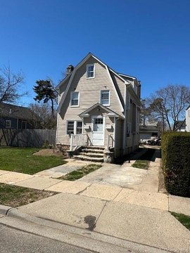
275 Merrick Rd Freeport, NY 11520-3346
Property profile & analytics
275 Merrick Rd, Freeport, NY 11520-3346
- Assisted living facilities
- 13,736 SF
- 0.99 lot acres
Property ID
US63-2911263
The Realmo ID is a unique identifier assigned to every property, incorporating country codes and precise geo-coordinates for 300x300-foot land blocks. It enables standardized data collection and seamless integration of disparate sources such as ownership, tax, title data and physical specifications. By aggregating current and historical records, the Realmo ID powers advanced analytics and delivers deep, verifiable insights for real estate professionals.
Location Intelligence
Current Use by Public Records
- South Shore Rehabilitation and Nursing Center / Rehabilitation Center / Nursing Home
- South shore / Government Office
Property Details for 275 Merrick Rd
- Year built
- 1959
- Construction
- MASONRY/CONCRETE MASONRY UNITS (CMUS)
- Lot size
- 0.99 lot acres
- Property type
- Assisted living facilities
- Property subtype
- Retirement homes
- APN
- 62-126-00-0197
- APU
- 62126000197
Sales History
| Date | Price | Buyer | Seller | Deed Type | Mortgage |
|---|---|---|---|---|---|
| Mar 29, 2023 | — | South Shore Rehabilitation LLC | South Shore Nursing Realty LLC | Lease | $1.7M · Dwight Capital LLC |
| Apr 13, 2021 | — | South Shore Nursing Realty LLC | — | Deed · related | $4.3M · Bankwell Bank |
| Oct 7, 2013 | $6,250,000 | South Shore Nursing Realty LLC | S S N H R INC | Grant Deed | $394k · Peoples United Bank |
| May 21, 1991 | $749,750 | S S N H R INC | Unknown | Grant Deed | — |
| — | — | South Shore Nursing Realty LLC | — | Deed Of Trust · related | $1.5M · Peoples United Bank |
| — | — | South Shore Nursing Realty LLC | — | Deed Of Trust · related | $4.1M · People's United Bk |
| — | — | South Shore Nursing Realty LLC | — | Loan Modification · related | $5.3M · People's United Bk |
| — | — | Ssnhr INC | — | Deed Of Trust · related | $6.3M · Archon Financial LP |
Value Estimations
based on Realmo’s proprietary methodology
-
AI approach
- Method
- Estimation
- Statistic approach
- $6,150,000
- ML approach
- $6,555,000
-
Alternative Use
- Use
- Estimation
- COMMERCIAL (GENERAL)
- $5,135,000
- APARTMENT HOUSE (5+ UNITS)
- $3,850,000
Get a detailed, property-specific estimation — fast and free
Location Insight
- Map
- Local Demand
- City
- Freeport
- County
- Nassau
- State
- New York
- Longitude
- -73.592
- Latitude
- 40.6518
- CBSA code
- 35620
- CBSA name
- NEW YORK-NORTHERN NEW JERSEY-LONG ISLAND, NY-NJ-PA METROPOLITAN STATISTICAL AREA
Property Tax & Assessments
Tax date
Tax Amount
Assessed Land Value
Assessed Improvement Value
Total Assessed Value
Applied Tax Rate
Land Market Value
Improvement Market Value
Total Market Value
2023
$138,228
$11,034
$23,774
$34,808
-
$0.00
$0.00
$3,480,800