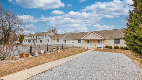
264 Wheat Rd Vineland, NJ 08360
R-2 and R-P Zones, so as to provide varied housing opportunities within the City. It is important that zone requirements and design standards not be sacrificed to allow overdevelopment of properties, as this would negatively impact upon the character of these neighborhoods. It is the intent that a single-family dwelling be the preferred use of property, as n…
Cap rate
Implied · in-place · derived from last sale + estimated NOIValue
AI, CAP & Alternative Use estimations · Realmo proprietary blendProperty tax & assessments
Tax year 2022Comparables
6 recent transactions · within 1.5 miComparable in this City


Similar Nearby for Sale


Similar Nearby for Lease


Property description
Physical attributes from public recordsZoning & alternative use
R-2 · Vineland, NJR-2 and R-P Zones, so as to provide varied housing opportunities within the City. It is important that zone requirements and design standards not be sacrificed to allow overdevelopment of properties, as this would negatively impact upon the character of these neighborhoods. It is the intent that a single-family dwelling be the preferred use of property, as none of the other permitted uses are to be considered unless all other requirements of this chapter can be met. For example, there is no automatic or implied right to develop a two-family dwelling. A two-family dwelling should only be considered if all the requirements of this chapter, including design standards, can be met. B. Permitted uses. Permitted uses within the R-3 Residential Zone shall be as follows: (1) Single-family dwelling. [1] [1]
Costs & Benchmarks
Operating expenses, capex projections, utility benchmarks, and submarket comparables — all in one view.
Risks
Flood, climate, environmental, title, and tenant-concentration risk — surfaced with mitigations and source citations.


