New search
Property profile & analytics
FOR LEASE
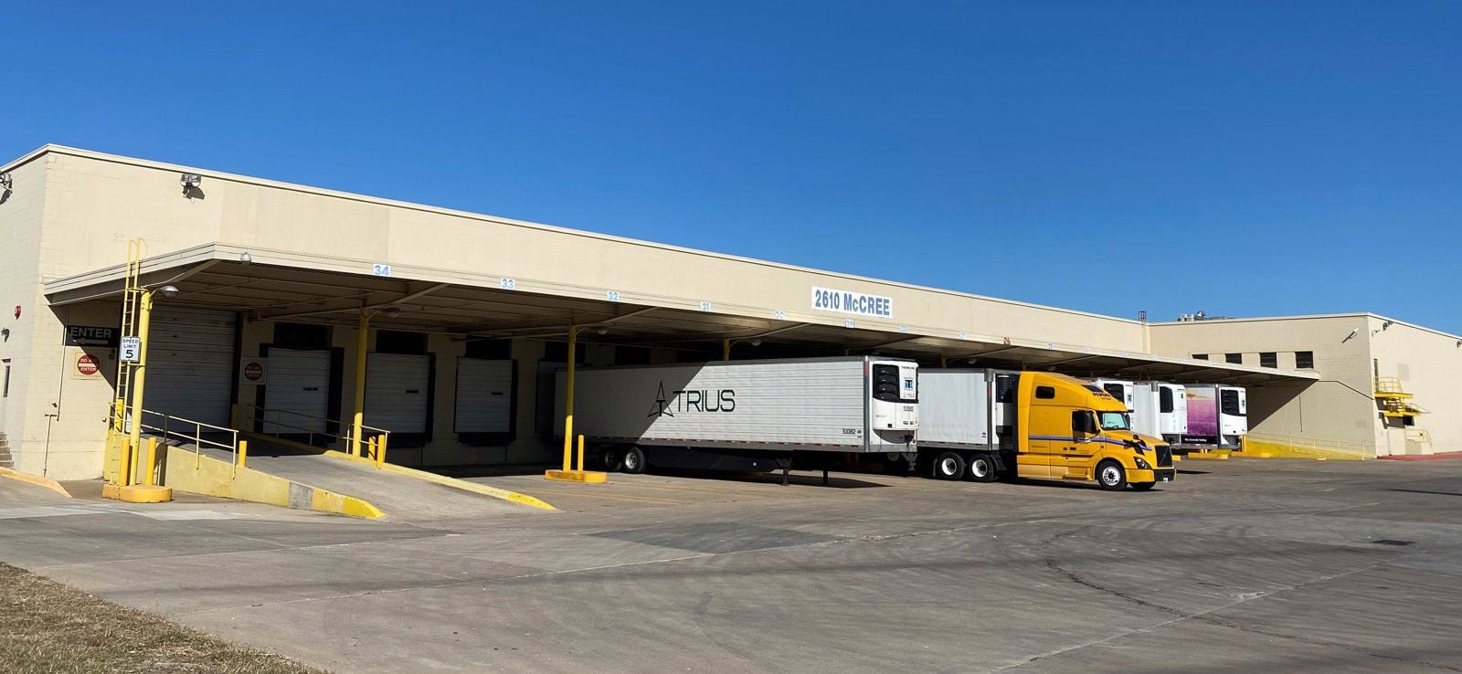
Warehouses
2610 Mccree Rd Garland, TX 75041
Entity Owned
Absentee Owner
~
Est. High Equity
Property ID
US82-5474852
 For Lease
$1,865,000
2610 Mccree Rd, Garland, TX 75041
View Listing →
Property profile
Verified
Property type
Warehouses
Use group
MINI-WAREHOUSE, STORAGE
Year built
1971
Construction
TILT-UP CONCRETE
Total area
156,858 SF
Lot
9.79 ac (426,670 SF)
APN
263285000102R0000
UPID
US82-5474852
Cap rate & NOI
Priority signal for investors
Implied cap rate, NOI & suggested price
Cap rate vs submarket · NOI estimate · 3 price anchors
Implied cap rate, NOI & suggested price
Cap vs submarket · NOI estimate · 3 price anchors
Current use
Occupant on record · Public records
-
Fixture Max Big Box & Wholesale Store
Value estimations
Realmo proprietary · 4 methods
AI Approach
AI
by Request
CAP Approach
CAP
by Request
Comparable Approach
Comparable
by Request
Blend (final)
Blend
$1.87M
Owner & transaction history
Scout Cold Storage Dallas LP
Scout Cold Storage Dallas LP
since 2026
2 recorded transactions
Zoning & alternative use
Permitted uses
Permitted uses
Allowed · conditional · prohibited
Cap rate
Implied · in-place · derived from last sale + estimated NOI
Implied Cap rate
#1
Implied · in-place · NOI ÷ last sale
In-place · derived from last sale + estimated NOI
Cap rate, NOI & submarket benchmark
Implied cap rate vs Garland submarket · NOI estimate · Typical band, median & reading
Implied cap rate, NOI & submarket benchmark
Cap vs Garland submarket · NOI estimate · typical band, median & reading
Refine your cap rate
8-question underwriting flow
1.
Property current status — Going-In vs Stabilized
2.
Price for denominator — asking / offer / market
3.
Leasing status & lease structure (NNN / Gross)
4.
Tenant risk profile & vacancy assumption
5.
Upload T12 / rent roll / OM (optional)
Refine in 60 seconds, get exact suggested price
T12 upload · Submarket benchmarks · Sensitivity grid
Suggested price · 3 cap rate anchors
Income approach @ 5% / 7% / 9% — aggressive / typical / conservative
Suggested price at 5% / 7% / 9% cap
Aggressive / typical / conservative · Implied $/SF per anchor · Sensitivity grid
Suggested price at 5% / 7% / 9% cap
Aggressive / typical / conservative · implied $/SF · sensitivity
Value
AI, CAP & Alternative Use estimations · Realmo proprietary blendValue Estimations
Based on Realmo’s proprietary methodology
AI Approach
CAP Approach
Comparable Approach
Alternative Use
Get a detailed, property-specific estimation — fast and free
Price per SF
Sale + rent benchmarks
Subject property
$12 / SF
Submarket sale & rent benchmarks
Median sale $/SF · Asking & closed rent · Submarket vacancy
Submarket sale & rent benchmarks
Median sale $/SF · asking & closed rent · submarket vacancy
Property tax & assessments
Tax year 2023Property tax & assessments
Tax year 2023
Tax billed
$130,285
Tax year 2023
Assessed value
$5,793,450
Assessed 2023
Previous assessed
$5,793,450
+0.0% YoY
Effective rate
2.25%
On assessed value
Assessed land
$1,920,020
Assessed improvement
$3,873,430
Land market value
$1,920,020
Improvement market value
$3,873,430
Total market value
$5,793,450
Comparables
6 recent transactions · within 1.5 miComparable in this city
6 recent transactions
Comparable in this City


Similar Nearby for Sale


Similar Nearby for Lease


Recent comparable sales
Sale price & price/SF · Sale date & distance · Adjustments & confidence
Recent comparable sales
Sale price & $/SF · sale date & distance · adjustments
Property description
Physical attributes from public recordsBuilding & lot
Public records
Property type
Warehouses
Use group
MINI-WAREHOUSE, STORAGE
Status
For Lease
Year built
1971
Construction
TILT-UP CONCRETE
Heating
OTHER
Cooling
NONE
Stories
2
Total area
156,858 SF
Lot
9.79 ac (426,670 SF)
APN
263285000102R0000
UPID
US82-5474852
Jurisdiction
DALLAS
Metro division
DALLAS-PLANO-IRVING, TX METROPOLITAN DIVISION
Zoning & alternative use
Zoning · permitted uses
Permitted & conditional uses
Allowed uses · Special-permit conditions · Prohibited uses
Permitted & conditional uses
Allowed · special-permit conditions · prohibited
Building & site characteristics
From public records
Year built
1971
Construction
TILT-UP CONCRETE
Heating
OTHER
Cooling
Yes
Stories
2
Lot
9.79 ac
Current owner
From public records · entity-resolved
Scout Cold Storage Dallas LP
Entity
Mailing address
7058 SW 44TH STP2E, MIAMI, FL 33155-4609
Mailing matches property
Different — outreach signal
Owner-occupied
No
Ownership since
2026
Owner contacts — direct phone, email, and related entities
Decision-maker phone · Verified email · Related entities & filings
Owner contacts
Email · phone · related entities
Sales History
2 recorded events · public records
Date
Price
Buyer
Seller
Deed Type
Mortgage
Apr 21, 2026
—
Scout Cold Storage Dallas LP
—
Deed
related
$104,270,000 · Cuna Mutual Life Insurance Company
Dec 23, 2020
—
Scout Cold Storage Dallas LLC
—
Deed
related
$124,525,000 · Wells Fargo Bk
Coming soon
Costs & Benchmarks
Operating expenses, capex projections, utility benchmarks, and submarket comparables — all in one view.
Coming soon
Risks
Flood, climate, environmental, title, and tenant-concentration risk — surfaced with mitigations and source citations.
Try Rey
Ask anything about this address in plain English.
“Is 15.6% cap rate sustainable?” · “Best tenant mix for BU1?” · “What’s the redev upside?”
Full reports are paid
Unlock the full Property Analytics report
Start free for 7 days — no card required. Full owner contacts, all 4 valuations with methodology, refine flow, comparable adjustments, foot-traffic deep dive, export to PDF / CSV.


