2300 David Dr Bristol, PA 19007-2042
Property profile & analytics
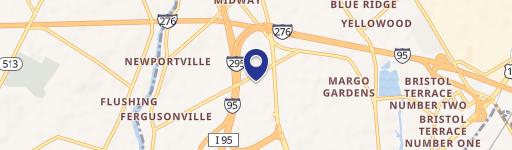
2300 David Dr, Bristol, PA 19007-2042
- Warehouses
- 18,683 SF
- 6.23 lot acres
Property ID
US73-4260699
The Realmo ID is a unique identifier assigned to every property, incorporating country codes and precise geo-coordinates for 300x300-foot land blocks. It enables standardized data collection and seamless integration of disparate sources such as ownership, tax, title data and physical specifications. By aggregating current and historical records, the Realmo ID powers advanced analytics and delivers deep, verifiable insights for real estate professionals.
Location Intelligence
Current Use by Public Records
- Warehouses
Property Details for 2300 David Dr
- Year built
- 1976
- Lot size
- 6.23 lot acres
- Zone code
- M2
- Property type
- Warehouses
- APN
- 05-028-534
- APU
- 5028534
Sales History
| Date | Price | Buyer | Seller | Deed Type | Mortgage |
|---|---|---|---|---|---|
| Nov 30, 2007 | $337,000 | Lee Realty | Tanney Family Ptshp | Grant Deed | — |
| Jun 24, 2005 | $145,000 | Lee Realty | Telford Indl Dev Authority | Grant Deed | — |
| Jun 24, 2005 | — | Lee Realty | T & L Associates | Grant Deed · related | — |
Value Estimations
based on Realmo’s proprietary methodology
-
Comparable approach
- Method
- Estimation
- Statistic Estimate
- $1,761,000
Market price range: $1.61M - $3.00M -
Alternative Use
- Use
- Estimation
- WAREHOUSE, STORAGE
- $2,050,000 Current use
Get a detailed, property-specific estimation — fast and free
Location Insight
- Map
- Local Demand
- City
- Bristol
- County
- Bucks
- State
- Pennsylvania
- Longitude
- -74.8704
- Latitude
- 40.1173
- CBSA code
- 37980
- CBSA name
- PHILADELPHIA-CAMDEN-WILMINGTON, PA-NJ-DE-MD METROPOLITAN STATISTICAL AREA
Property Tax & Assessments
Tax date
Tax Amount
Assessed Land Value
Assessed Improvement Value
Total Assessed Value
Applied Tax Rate
Land Market Value
Improvement Market Value
Total Market Value
2024
$26,440
$37,360
$60,000
$97,360
-
$511,779
$821,914
$1,333,693