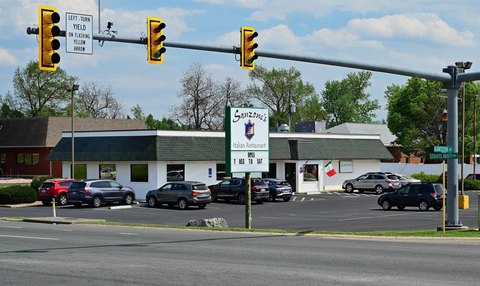
2083 Stuarts Draft Hwy Stuarts Draft, VA 24477
Property Lookup
Property profile & analytics
2083 Stuarts Draft Hwy Stuarts Draft, VA 24477
- Retail space
- 13,966 SF
- 3.91 lot acres
Property ID
US87-3328776
The Realmo ID is a unique identifier assigned to every property, incorporating country codes and precise geo-coordinates for 300x300-foot land blocks. It enables standardized data collection and seamless integration of disparate sources such as ownership, tax, title data and physical specifications. By aggregating current and historical records, the Realmo ID powers advanced analytics and delivers deep, verifiable insights for real estate professionals.
Location Intelligence
Current Use by Public Records
- Retail space
Property Details for 2083 Stuarts Draft Hwy
- Year built
- 1981
- Lot size
- 3.91 lot acres
- Property size
- 13,966 SF
- Zone code
- GENERAL BUSINESS
- Property type
- Retail space
- APN
- 083 77B
- APU
- 08377B
Value Estimations
based on Realmo’s proprietary methodology
-
Alternative Use
- Use
- Estimation
- RETAIL STORES
- $560,000 Current use
- AUTO REPAIR, GARAGE
- $870,000 Change: +55% Conversion: Difficult
- MEDICAL BUILDING
- $750,000 Change: +34% Conversion: Difficult
- WAREHOUSE, STORAGE
- $555,000 Change: -1% Conversion: Difficult
Get a detailed, property-specific estimation — fast and free
Location Insight
- Map
- Local Demand
- City
- Stuarts Draft
- County
- Augusta
- State
- Virginia
- Longitude
- -79.0608
- Latitude
- 38.0303
- CBSA code
- 44420
- CBSA name
- STAUNTON-WAYNESBORO, VA MICROPOLITAN STATISTICAL AREA
Property Tax & Assessments
Tax date
Tax Amount
Assessed Land Value
Assessed Improvement Value
Total Assessed Value
Applied Tax Rate
Land Market Value
Improvement Market Value
Total Market Value
2023
$4,627
$265,700
$1,752,400
$2,018,100
-
$265,700
$1,752,400
$2,018,100