Back to Search
Property profile & analytics
OFF-MARKET
Office Spaces
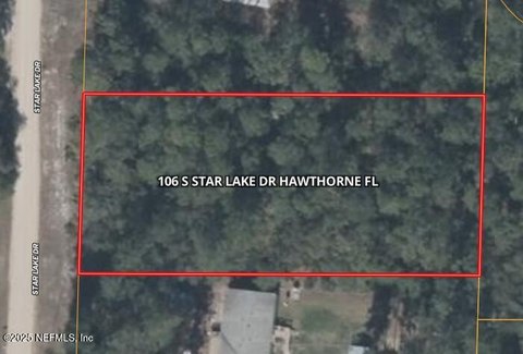
18120 State Rd 26 Hawthorne, FL 32640-9287
Trust Owned
6-yr Hold
Free & Clear
Property ID
US18-6028437
Property profile
Verified
Property type
Office Spaces
Use group
CONDOMINIUM OFFICES
Lot
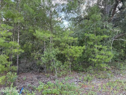
2.89 ac (125,888 SF)
Zoning code
A
APN
18813-001-000
UPID
US18-6028437
Cap rate & NOI
Priority signal for investors
Implied cap rate, NOI & suggested price
Cap rate vs submarket · NOI estimate · 3 price anchors
Implied cap rate, NOI & suggested price
Cap vs submarket · NOI estimate · 3 price anchors
Value estimations
Realmo proprietary · 4 methods
AI Approach
AI
by Request
CAP Approach
CAP
by Request
Comparable Approach
Comparable
by Request
Blend (final)
Blend
by Request
Owner & transaction history
Brown,r R & K Fam Trust · 6 yrs held
Brown,r R & K Fam Trust
since 2019
4 recorded transactions
Zoning & alternative use
A · Hawthorne, FL
Permitted uses
Permitted uses
Allowed · conditional · prohibited
Zoning description
Lands in these districts are intended to provide for areas primarily consisting of agricultural and residential uses consistent with the areas as designated agricultural within the city's comprehensive plan
Zone name
Agricultural
General category
RESIDENTIAL
Zone area
2,108.25 ac
Source
Realmo
Cap rate
Implied · in-place · derived from last sale + estimated NOI
Implied Cap rate
#1
Implied · in-place · NOI ÷ last sale
In-place · derived from last sale + estimated NOI
Cap rate, NOI & submarket benchmark
Implied cap rate vs Hawthorne submarket · NOI estimate · Typical band, median & reading
Implied cap rate, NOI & submarket benchmark
Cap vs Hawthorne submarket · NOI estimate · typical band, median & reading
Refine your cap rate
8-question underwriting flow
1.
Property current status — Going-In vs Stabilized
2.
Price for denominator — asking / offer / market
3.
Leasing status & lease structure (NNN / Gross)
4.
Tenant risk profile & vacancy assumption
5.
Upload T12 / rent roll / OM (optional)
Refine in 60 seconds, get exact suggested price
T12 upload · Submarket benchmarks · Sensitivity grid
Suggested price · 3 cap rate anchors
Income approach @ 5% / 7% / 9% — aggressive / typical / conservative
Suggested price at 5% / 7% / 9% cap
Aggressive / typical / conservative · Implied $/SF per anchor · Sensitivity grid
Suggested price at 5% / 7% / 9% cap
Aggressive / typical / conservative · implied $/SF · sensitivity
Value
AI, CAP & Alternative Use estimations · Realmo proprietary blendValue Estimations
Based on Realmo’s proprietary methodology
AI Approach
CAP Approach
Comparable Approach
Alternative Use
Get a detailed, property-specific estimation — fast and free
Price per SF
Sale + rent benchmarks
Subject property
—
Submarket sale & rent benchmarks
Median sale $/SF · Asking & closed rent · Submarket vacancy
Submarket sale & rent benchmarks
Median sale $/SF · asking & closed rent · submarket vacancy
Property tax & assessments
Tax year 2023Property tax & assessments
Tax year 2023
Tax billed
$58
Tax year 2023
Assessed value
$1,783
Assessed 2023
Previous assessed
$1,783
+0.0% YoY
Effective rate
3.25%
On assessed value
Land market value
$900
Improvement market value
$31,773
Total market value
$32,673
Applied tax rate
200.0000
Comparables
6 recent transactions · within 1.5 miComparable in this city
6 recent transactions
Comparable in this City


Similar Nearby for Sale


Similar Nearby for Lease


Recent comparable sales
Sale price & price/SF · Sale date & distance · Adjustments & confidence
Recent comparable sales
Sale price & $/SF · sale date & distance · adjustments
Property description
Physical attributes from public recordsBuilding & lot
Public records
Property type
Office Spaces
Use group
CONDOMINIUM OFFICES
Status
Off-Market
Heating
NONE
Lot
2.89 ac (125,888 SF)
Zoning code
A
APN
18813-001-000
UPID
US18-6028437
Jurisdiction
ALACHUA
Zoning & alternative use
A · Hawthorne, FLZoning A · permitted uses
A · Hawthorne, FL
Permitted & conditional uses
Allowed uses · Special-permit conditions · Prohibited uses
Permitted & conditional uses
Allowed · special-permit conditions · prohibited
Zoning description
Lands in these districts are intended to provide for areas primarily consisting of agricultural and residential uses consistent with the areas as designated agricultural within the city's comprehensive plan
Zone name
Agricultural
General category
RESIDENTIAL
Zone area
2,108.25 ac
Source
Realmo
Building & site characteristics
From public records
Heating
NONE
Lot
2.89 ac
Current owner
From public records · entity-resolved
Brown,r R & K Fam Trust
Trust
Free & Clear · 6 yrs held
Mailing address
7105 NE 179TH ST, HAWTHORNE, FL 32640-9235
Ownership since
2019
Owner contacts — direct phone, email, and related entities
Decision-maker phone · Verified email · Related entities & filings
Owner contacts
Email · phone · related entities
Sales History
4 recorded events · public records
Date
Price
Buyer
Seller
Deed Type
Mortgage
Oct 21, 2019
$100
Brown,r R & K Fam Trust
Roy R Brown
Grant Deed
related
—
Jul 22, 2019
$100
Roy R Brown
Brown,reginald L
Quit Claim Deed
related
—
Aug 29, 2008
—
Owner Name Unavailable
Owner Name Unavailable
Quit Claim Deed
related
—
Aug 13, 2003
—
Department Of Transportation
Brown,ralph L & Lola B
Grant Deed
related
—
Coming soon
Costs & Benchmarks
Operating expenses, capex projections, utility benchmarks, and submarket comparables — all in one view.
Coming soon
Risks
Flood, climate, environmental, title, and tenant-concentration risk — surfaced with mitigations and source citations.
Try Rey
Ask anything about this address in plain English.
“Is 15.6% cap rate sustainable?” · “Best tenant mix for BU1?” · “What’s the redev upside?”
You own 18120 State Rd 26?
List it free. Reach 20,000 daily buyers.
We’ve already pulled the facts. Confirm photos + price and you’re live in 2 minutes.
List this address →
Full reports are paid
Unlock the full Property Analytics report
Start free for 7 days — no card required. Full owner contacts, all 4 valuations with methodology, refine flow, comparable adjustments, foot-traffic deep dive, export to PDF / CSV.


