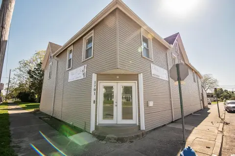
1801 High St Springfield, OH 45505-5203
Property profile & analytics
1801 High St, Springfield, OH 45505-5203
- Garden apartment buildings
- 2,392 SF
- 0.20 lot acres
Property ID
US66-2448149
The Realmo ID is a unique identifier assigned to every property, incorporating country codes and precise geo-coordinates for 300x300-foot land blocks. It enables standardized data collection and seamless integration of disparate sources such as ownership, tax, title data and physical specifications. By aggregating current and historical records, the Realmo ID powers advanced analytics and delivers deep, verifiable insights for real estate professionals.
Location Intelligence
Current Use by Public Records
- Garden apartment buildings
Property Details for 1801 High St
- Year built
- 1946
- Construction
- FRAME
- Lot size
- 0.20 lot acres
- Property type
- Garden apartment buildings
- APN
- 340-07-00028-205-009
- APU
- 3400700028205009
Sales History
| Date | Price | Buyer | Seller | Deed Type | Mortgage |
|---|---|---|---|---|---|
| Jan 8, 2024 | $201,700 | 1801 E High St LLC | Sixtyft Sixin LLC | Warranty Deed | $151k · Vontive INC |
| May 17, 2013 | $78,500 | Sixtyft Sixin LLC | Mcneil Donald P Trust | Grant Deed | $63k · Perpetual Fsb |
| — | — | Mcneil,donald P Tr | — | Deed Of Trust · related | $26k · Huntington National Bank |
Value Estimations
based on Realmo’s proprietary methodology
-
AI approach
-
CAP approach
-
Comparable approach
-
Alternative Use
Get a detailed, property-specific estimation — fast and free
Location Insight
- Map
- Local Demand
- City
- Springfield
- County
- Clark
- State
- Ohio
- Longitude
- -83.7826
- Latitude
- 39.9211
- CBSA code
- 44220
- CBSA name
- SPRINGFIELD, OH METROPOLITAN STATISTICAL AREA
Property Tax & Assessments
Tax date
Tax Amount
Assessed Land Value
Assessed Improvement Value
Total Assessed Value
Applied Tax Rate
Land Market Value
Improvement Market Value
Total Market Value
2022
$0.00
$2,480
$24,050
$26,530
-
$7,080
$68,710
$75,790