
1559 10th St, Jeffersonville, IN 47130-4567
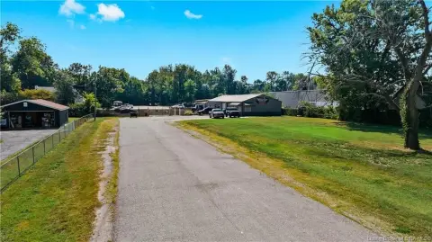
This exceptional 2.12-acre commercial land parcel presents a unique investment opportunity in Jeffersonville, Indiana. Located at 1559 E 10th St, this property boasts a highly desirable C2 zoning classification, complemented by an MP designation, offering significant development potential. The expansive lot size provides ample space for a variety of commercial ventures. Situated on a four-lane thoroughfare, E 10th St, this location ensures high visibility and accessibility, making it an ideal site for businesses seeking strong exposure. The property's APN is 101901000558000010f. With a total asking price of $160,000, this translates to a land value of approximately $80,188 per acre, representing a compelling price point for this prime commercial real estate. The property is conveniently located in Clark County, Indiana, with a zip code of 47130, and its geographic coordinates are 38.2956999 latitude and -85.7276347 longitude. This site is ready for your vision. Don't miss this chance to acquire a strategically located commercial property with significant growth potential.
Cap rate
Implied · in-place · derived from last sale + estimated NOIValue
AI, CAP & Alternative Use estimations · Realmo proprietary blendProperty tax & assessments
Tax year 2023Comparables
6 recent transactions · within 1.5 miComparable in this City


Similar Nearby for Sale


Similar Nearby for Lease


Property description
Physical attributes from public recordsZoning & alternative use
Costs & Benchmarks
Operating expenses, capex projections, utility benchmarks, and submarket comparables — all in one view.
Risks
Flood, climate, environmental, title, and tenant-concentration risk — surfaced with mitigations and source citations.


