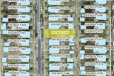
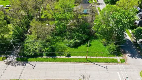
1509 Kendall St South Bend, IN 46613-1842
Property profile & analytics
1509 Kendall St, South Bend, IN 46613-1842
- Industrial land
- 2.83 lot acres
Property ID
US31-2674983
The Realmo ID is a unique identifier assigned to every property, incorporating country codes and precise geo-coordinates for 300x300-foot land blocks. It enables standardized data collection and seamless integration of disparate sources such as ownership, tax, title data and physical specifications. By aggregating current and historical records, the Realmo ID powers advanced analytics and delivers deep, verifiable insights for real estate professionals.
Location Intelligence
Current Use by Public Records
- Industrial land
Property Details for 1509 Kendall St
- Lot size
- 2.83 lot acres
- Property type
- Industrial land
- APN
- 71-08-14-276-003.000-026
- APU
- 710814276003000026
Sales History
| Date | Price | Buyer | Seller | Deed Type | Mortgage |
|---|---|---|---|---|---|
| Oct 17, 2014 | $2,301 | South Bend City Dept Of Redev | St Joseph County Auditor | Sheriffs Deed · related | — |
| Nov 22, 2011 | — | Data Realty Northern Indiana LLC | City Of South Bend Department Of Re | Limited Warranty Deed | — |
| Apr 26, 2007 | — | City Of South | Norfolk Sougthern Railwway Co | Quit Claim Deed · related | — |
Value Estimations
based on Realmo’s proprietary methodology
-
AI approach
-
CAP approach
-
Comparable approach
-
Alternative Use
Get a detailed, property-specific estimation — fast and free
Location Insight
- Map
- Local Demand
- City
- South Bend
- County
- St. Joseph
- State
- Indiana
- Longitude
- -86.2595
- Latitude
- 41.6599
- CBSA code
- 43780
- CBSA name
- SOUTH BEND-MISHAWAKA, IN-MI METROPOLITAN STATISTICAL AREA
Property Tax & Assessments
Tax date
Tax Amount
Assessed Land Value
Assessed Improvement Value
Total Assessed Value
Applied Tax Rate
Land Market Value
Improvement Market Value
Total Market Value
2023
$633
$18,700
$0.00
$18,700
-
$18,700
$0.00
$18,700