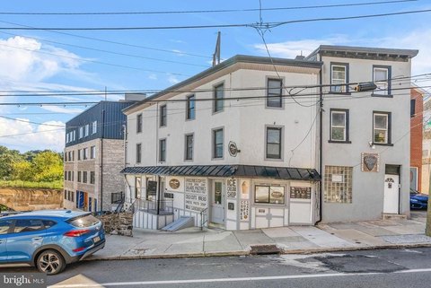
141 Krams Ave Philadelphia, PA 19127-2075
-
Parish House Manayunk Apartment Complex
tial Single-Family Detached-3 R2 RSA-1 Residential Single-Family Attached-1 R3 RSA-2 Residential Single-Family Attached-2 R4 RSA-3 Residential Single-Family Attached-3 R5 RSA-4 Residential Single-Family Attached-4 R6 R7 RSA-5 Residential Single-Family Attached-5 R9A R10A R20 RSA-6 Residential Single-Family Attached-6 NA (new district) RTA-1 Residential Two-F…
Cap rate
Implied · in-place · derived from last sale + estimated NOIValue
AI, CAP & Alternative Use estimations · Realmo proprietary blendProperty tax & assessments
Tax year 2023Comparables
6 recent transactions · within 1.5 miComparable in this City


Similar Nearby for Sale


Similar Nearby for Lease


Property description
Physical attributes from public recordsZoning & alternative use
RSA5 · Philadelphia, PAtial Single-Family Detached-3 R2 RSA-1 Residential Single-Family Attached-1 R3 RSA-2 Residential Single-Family Attached-2 R4 RSA-3 Residential Single-Family Attached-3 R5 RSA-4 Residential Single-Family Attached-4 R6 R7 RSA-5 Residential Single-Family Attached-5 R9A R10A R20 RSA-6 Residential Single-Family Attached-6 NA (new district) RTA-1 Residential Two-Family Attached-1 R5A RTA-2 Residential Two-Family Attached-2 NA (new district) RM-1 R
Costs & Benchmarks
Operating expenses, capex projections, utility benchmarks, and submarket comparables — all in one view.
Risks
Flood, climate, environmental, title, and tenant-concentration risk — surfaced with mitigations and source citations.


