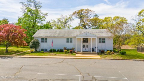
139 Grant Ave Eatontown, NJ 07724-1306
Property profile & analytics
139 Grant Ave Eatontown, NJ 07724-1306
- Commercial real estate
- 54,867 SF
- 7.00 lot acres
Property ID
US59-3061311
The Realmo ID is a unique identifier assigned to every property, incorporating country codes and precise geo-coordinates for 300x300-foot land blocks. It enables standardized data collection and seamless integration of disparate sources such as ownership, tax, title data and physical specifications. By aggregating current and historical records, the Realmo ID powers advanced analytics and delivers deep, verifiable insights for real estate professionals.
Location Intelligence
Current Use by Public Records
- Commercial real estate
Property Details for 139 Grant Ave
- Year built
- 1965
- Lot size
- 7.00 lot acres
- Property size
- 54,867 SF
- Zone code
- R10
- Property type
- Commercial real estate
- APN
- 12 01601-0000-00036
- APU
- 1201601000000036
Value Estimations
based on Realmo’s proprietary methodology
-
Comparable approach
- Method
- Estimation
- AI Estimate
- $4,249,000
Market price range: $1.44M - $7.48M -
Alternative Use
- Use
- Estimation
- COMMERCIAL (GENERAL)
- $11,565,000 Current use
- INDUSTRIAL (GENERAL)
- $11,310,000 Change: -2% Conversion: Moderate
Get a detailed, property-specific estimation — fast and free
Location Insight
- Map
- Local Demand
- City
- Eatontown
- County
- Monmouth
- State
- New Jersey
- Longitude
- -74.0624
- Latitude
- 40.2931
- CBSA code
- 35620
- CBSA name
- NEW YORK-NORTHERN NEW JERSEY-LONG ISLAND, NY-NJ-PA METROPOLITAN STATISTICAL AREA
Property Tax & Assessments
Tax date
Tax Amount
Assessed Land Value
Assessed Improvement Value
Total Assessed Value
Applied Tax Rate
Land Market Value
Improvement Market Value
Total Market Value
2022
$196,923
$2,660,000
$7,317,700
$9,977,700
-
$2,660,000
$7,317,700
$9,977,700