134 Sandy Dr Newark, DE 19713-1147
Property profile & analytics
134 Sandy Dr, Newark, DE 19713-1147
- Warehouses
- 10,244 SF
- 2.07 lot acres
Property ID
US17-0141600
The Realmo ID is a unique identifier assigned to every property, incorporating country codes and precise geo-coordinates for 300x300-foot land blocks. It enables standardized data collection and seamless integration of disparate sources such as ownership, tax, title data and physical specifications. By aggregating current and historical records, the Realmo ID powers advanced analytics and delivers deep, verifiable insights for real estate professionals.
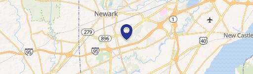
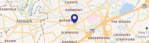
Location Intelligence
Current Use by Public Records
- Joint Analytical Systems / Chemical Plant
Property Details for 134 Sandy Dr
- Year built
- 1999
- Construction
- CONCRETE
- Lot size
- 2.07 lot acres
- Zone code
- 18MI
- Property type
- Warehouses
- APN
- 18-038.00-022
- APU
- 1803800022
Sales History
| Date | Price | Buyer | Seller | Deed Type | Mortgage |
|---|---|---|---|---|---|
| Jun 26, 2024 | — | Boyce Landholdings LLC | — | Deed · related | $908k · Delaware Community Development Corporati |
| Jun 13, 2024 | — | Boyce Landholdings LLC | — | Deed · related | $908k · Delaware Community Development Corporati |
| May 24, 2024 | — | Boyce Landholdings LLC | 715 King Series Series Of Owls Nest | Special Warranty Deed | $1.1M · Pnc Bank NA |
| Jul 6, 2017 | $1,250,000 | 715 King Series Owls Nest Propertie | Joint Analytical Systems INC | Deed | $400k · Wilmington Savings Fund Society Fsb |
| Feb 1, 2011 | $1,040,000 | Joint Analytical Systems Americas I | Accuvention LLC | Deed | $809k · Wilmington Savings Fund Society Fsb |
| — | — | Accuvention LLC | — | Deed Of Trust · related | $850k · Citizens Federal Bank Fsb |
Value Estimations
based on Realmo’s proprietary methodology
-
CAP approach
- CAP Return
- Estimation
- 6%
- $1,330,000
- 6.5%
- $1,230,000
- 7%
- $1,140,000
-
Alternative Use
- Use
- Estimation
- WAREHOUSE, STORAGE
- $1,410,000 Current use
Get a detailed, property-specific estimation — fast and free
Location Insight
- Map
- Local Demand
- City
- Newark
- County
- New Castle
- State
- Delaware
- Longitude
- -75.7696
- Latitude
- 39.6589
- CBSA code
- 37980
- CBSA name
- PHILADELPHIA-CAMDEN-WILMINGTON, PA-NJ-DE-MD METROPOLITAN STATISTICAL AREA
Property Tax & Assessments
Tax date
Tax Amount
Assessed Land Value
Assessed Improvement Value
Total Assessed Value
Applied Tax Rate
Land Market Value
Improvement Market Value
Total Market Value
2024
$14,798
$72,500
$326,900
$399,400
-
$0.00
$0.00
$0.00