Back to Search
Property profile & analytics
OFF-MARKET
Gas stations
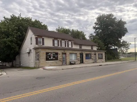
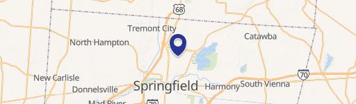
1321 Moorefield Rd Springfield, OH 45503-5661
Entity Owned
8-yr Hold
~
Est. High Equity
Property ID
US66-2446401
Property profile
Verified
Property type
Gas stations
Use group
SERVICE STATION (FULL SERVICE)
Year built
1963
Construction
CONCRETE BLOCKS
Total area
3,059 SF
Lot
0.53 ac (23,087 SF)
Zoning code
B-2
APN
220-03-00027-212-018
UPID
US66-2446401
Cap rate & NOI
Priority signal for investors
Implied cap rate, NOI & suggested price
Cap rate vs submarket · NOI estimate · 3 price anchors
Implied cap rate, NOI & suggested price
Cap vs submarket · NOI estimate · 3 price anchors
Current use
Occupant on record · Public records
-
Board's Northridge Car Care Car Wash
-
Sunoco Gas Station
-
Marathon Gas Grocery & Convenience Store
-
Bitstop Bitcoin ATM Atm
-
LibertyX Bitcoin ATM Atm
Value estimations
Realmo proprietary · 4 methods
AI Approach
AI
by Request
CAP Approach
CAP
by Request
Comparable Approach
Comparable
by Request
Blend (final)
Blend
by Request
Owner & transaction history
Moorefield Enterprises INC · 8 yrs held
Moorefield Enterprises INC
since 2018
5 recorded transactions
Zoning & alternative use
B-2 · Springfield, OH
Permitted uses
Permitted uses
Allowed · conditional · prohibited
Cap rate
Implied · in-place · derived from last sale + estimated NOI
Implied Cap rate
#1
Implied · in-place · NOI ÷ last sale
In-place · derived from last sale + estimated NOI
Cap rate, NOI & submarket benchmark
Implied cap rate vs Springfield submarket · NOI estimate · Typical band, median & reading
Implied cap rate, NOI & submarket benchmark
Cap vs Springfield submarket · NOI estimate · typical band, median & reading
Refine your cap rate
8-question underwriting flow
1.
Property current status — Going-In vs Stabilized
2.
Price for denominator — asking / offer / market
3.
Leasing status & lease structure (NNN / Gross)
4.
Tenant risk profile & vacancy assumption
5.
Upload T12 / rent roll / OM (optional)
Refine in 60 seconds, get exact suggested price
T12 upload · Submarket benchmarks · Sensitivity grid
Suggested price · 3 cap rate anchors
Income approach @ 5% / 7% / 9% — aggressive / typical / conservative
Suggested price at 5% / 7% / 9% cap
Aggressive / typical / conservative · Implied $/SF per anchor · Sensitivity grid
Suggested price at 5% / 7% / 9% cap
Aggressive / typical / conservative · implied $/SF · sensitivity
Value
AI, CAP & Alternative Use estimations · Realmo proprietary blendValue Estimations
Based on Realmo’s proprietary methodology
AI Approach
CAP Approach
Comparable Approach
Alternative Use
Get a detailed, property-specific estimation — fast and free
Price per SF
Sale + rent benchmarks
Subject property
—
Submarket sale & rent benchmarks
Median sale $/SF · Asking & closed rent · Submarket vacancy
Submarket sale & rent benchmarks
Median sale $/SF · asking & closed rent · submarket vacancy
Property tax & assessments
Tax year 2022Property tax & assessments
Tax year 2022
Assessed value
$41,890
Assessed 2023
Previous assessed
$41,890
+0.0% YoY
Assessed land
$6,460
Assessed improvement
$35,430
Land market value
$18,470
Improvement market value
$101,220
Total market value
$119,690
Applied tax rate
220.0000
Comparables
6 recent transactions · within 1.5 miComparable in this city
6 recent transactions
Comparable in this City


Similar Nearby for Sale


Similar Nearby for Lease


Recent comparable sales
Sale price & price/SF · Sale date & distance · Adjustments & confidence
Recent comparable sales
Sale price & $/SF · sale date & distance · adjustments
Property description
Physical attributes from public recordsBuilding & lot
Public records
Property type
Gas stations
Use group
SERVICE STATION (FULL SERVICE)
Status
Off-Market
Year built
1963
Construction
CONCRETE BLOCKS
Heating
NONE
Stories
1
Total area
3,059 SF
Lot
0.53 ac (23,087 SF)
Zoning code
B-2
APN
220-03-00027-212-018
UPID
US66-2446401
Jurisdiction
CLARK
Zoning & alternative use
B-2 · Springfield, OHZoning B-2 · permitted uses
B-2 · Springfield, OH
Permitted & conditional uses
Allowed uses · Special-permit conditions · Prohibited uses
Permitted & conditional uses
Allowed · special-permit conditions · prohibited
Building & site characteristics
From public records
Year built
1963
Construction
CONCRETE BLOCKS
Heating
NONE
Stories
1
Lot
0.53 ac
Current owner
From public records · entity-resolved
Moorefield Enterprises INC
Entity
Mailing address
1321 MOOREFIELD RD, SPRINGFIELD, OH 45503-5661
Mailing matches property
Yes
Owner-occupied
Yes
Ownership since
2018
Owner contacts — direct phone, email, and related entities
Decision-maker phone · Verified email · Related entities & filings
Owner contacts
Email · phone · related entities
Sales History
5 recorded events · public records
Date
Price
Buyer
Seller
Deed Type
Mortgage
Sep 4, 2024
—
Moorefield Enterprises INC
—
Deed
related
$1,500,000 · Park National Bank
Dec 20, 2023
—
Moga 2 LLC
—
Deed
related
$865,000 · Park National Bank
Mar 14, 2018
$400,000
Moorefield Enterprises INC
Sabri I Salhieh
Warranty Deed
$320,000 · Security National Bank
—
—
Board Family Trust
—
Deed Of Trust
related
$1,129,835 · Liberty National Bank
—
—
Board Family Trust
—
Deed Of Trust
related
$70,000 · Liberty National Bank
Coming soon
Costs & Benchmarks
Operating expenses, capex projections, utility benchmarks, and submarket comparables — all in one view.
Coming soon
Risks
Flood, climate, environmental, title, and tenant-concentration risk — surfaced with mitigations and source citations.
Try Rey
Ask anything about this address in plain English.
“Is 15.6% cap rate sustainable?” · “Best tenant mix for BU1?” · “What’s the redev upside?”
You own 1321 Moorefield Rd?
List it free. Reach 20,000 daily buyers.
We’ve already pulled the facts. Confirm photos + price and you’re live in 2 minutes.
List this address →
Full reports are paid
Unlock the full Property Analytics report
Start free for 7 days — no card required. Full owner contacts, all 4 valuations with methodology, refine flow, comparable adjustments, foot-traffic deep dive, export to PDF / CSV.


