Property profile & analytics
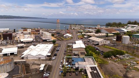
132 Kilauea Ave Hilo, HI 96720
- Retail properties & Spaces
OFF-MARKET
Value Estimations
Cap Rate Potential
Location Intelligence
Property ID
US24-0027305
The Realmo ID is a unique identifier assigned to every property, incorporating country codes and precise geo-coordinates for 300x300-foot land blocks. It enables standardized data collection and seamless integration of disparate sources such as ownership, tax, title data and physical specifications. By aggregating current and historical records, the Realmo ID powers advanced analytics and delivers deep, verifiable insights for real estate professionals.
Current Use by Public Records
- Retail properties & Spaces
Property Details for 132 Kilauea Ave
- Year built
- 1926
- Property type
- Retail properties & Spaces
Value Estimations
based on Realmo’s proprietary methodology
-
AI approach
-
CAP approach
-
Comparable approach
-
Alternative Use
Get a detailed, property-specific valuation — fast and free
Location Insight
- Map
- Local Demand
- City
- Hilo
- County
- Hawaii
- State
- Hawaii
- Longitude
- -155.0861
- Latitude
- 19.7224