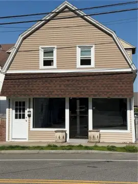
110 King Philip Rd Rumford, RI 02916-3517
Property profile & analytics
110 King Philip Rd, Rumford, RI 02916-3517
- Industrial properties
- 20,154 SF
- 0.64 lot acres
Property ID
US76-0136229
The Realmo ID is a unique identifier assigned to every property, incorporating country codes and precise geo-coordinates for 300x300-foot land blocks. It enables standardized data collection and seamless integration of disparate sources such as ownership, tax, title data and physical specifications. By aggregating current and historical records, the Realmo ID powers advanced analytics and delivers deep, verifiable insights for real estate professionals.
Location Intelligence
Current Use by Public Records
- Studio Rainwater / Marketing & Advertising / Advertising Agency
- Studio Eleven.26 / (Bike/Boat/Book/etc) Store / Photography Service
- Kay’s Kandids / Photography Service / (Bike/Boat/Book/etc) Store
- Stephanie Alvarez Ewens Photography / Photography Service / (Bike/Boat/Book/etc) Store
- Espy Creative Photography / Photography Service / (Bike/Boat/Book/etc) Store
Property Details for 110 King Philip Rd
- Year built
- 1940
- Lot size
- 0.64 lot acres
- Zone code
- I3
- Property type
- Industrial properties
- APN
- EPRO M:304 B:05 L:001 U:
- APU
- EPROM304B05L001U
Sales History
| Date | Price | Buyer | Seller | Deed Type | Mortgage |
|---|---|---|---|---|---|
| Nov 22, 2017 | — | Meta Industries LLC | — | Deed · related | $238k · Ocean State Bus Devel |
| Oct 28, 2016 | — | Meta Industries LLC | — | Deed · related | $99k · East Providence City |
| Jun 28, 2016 | $325,000 | Meta Industries LLC | King Philip Realty LLC | Warranty Deed | $328k · Pawtucket Cu |
| Jul 31, 2014 | — | King Philip Realty LLC | Weitzner,johathan A | Quit Claim Deed · related | — |
| Jun 23, 1997 | $230,000 | Jonathan A Weitzner | 110 King Philip Rd LLC | Grant Deed | $184k · Citizens Savings Bank |
| Sep 6, 1995 | $30,000 | 110 King Philip Rd LLC | Citizens Trust Co | Grant Deed | — |
| — | — | Meta Industries LLC | — | Deed Of Trust · related | $99k · East Providence City |
| — | — | Meta Industries LLC | — | Deed Of Trust · related | $238k · Ocean State Bus Devel |
Value Estimations
based on Realmo’s proprietary methodology
-
Alternative Use
- Use
- Estimation
- INDUSTRIAL (GENERAL)
- $1,670,000 Current use
Get a detailed, property-specific estimation — fast and free
Location Insight
- Map
- Local Demand
- City
- Rumford
- County
- Providence
- State
- Rhode Island
- Longitude
- -71.3656
- Latitude
- 41.8327
- CBSA code
- 39300
- CBSA name
- PROVIDENCE-NEW BEDFORD-FALL RIVER, RI-MA METROPOLITAN STATISTICAL AREA
Property Tax & Assessments
Tax date
Tax Amount
Assessed Land Value
Assessed Improvement Value
Total Assessed Value
Applied Tax Rate
Land Market Value
Improvement Market Value
Total Market Value
2024
$17,696
$132,100
$607,700
$739,800
-
$0.00
$0.00
$0.00