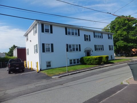
11 Mayor Thomas J Mcgrath Hwy Quincy, MA 02169-5311
Property profile & analytics
11 Mayor Thomas J Mcgrath Hwy, Quincy, MA 02169-5311
- Assisted living facilities
- 29,110 SF
- 1.01 lot acres
Property ID
US38-1385189
The Realmo ID is a unique identifier assigned to every property, incorporating country codes and precise geo-coordinates for 300x300-foot land blocks. It enables standardized data collection and seamless integration of disparate sources such as ownership, tax, title data and physical specifications. By aggregating current and historical records, the Realmo ID powers advanced analytics and delivers deep, verifiable insights for real estate professionals.
Location Intelligence
Current Use by Public Records
- Mary E. McDonagh, MSPT / Physician
Property Details for 11 Mayor Thomas J Mcgrath Hwy
- Year built
- 1965
- Construction
- MASONRY/CONCRETE MASONRY UNITS (CMUS)
- Lot size
- 1.01 lot acres
- Zone code
- BUSC
- Property type
- Assisted living facilities
- Property subtype
- Retirement homes
- APN
- QUIN M:1138 B:15 L:2
- APU
- QUINM1138B15L2
Sales History
| Date | Price | Buyer | Seller | Deed Type | Mortgage |
|---|---|---|---|---|---|
| Apr 24, 2026 | — | Galvin Qs Development LLC | — | Deed · related | $16M · Bank Of Canton |
| Mar 13, 2025 | — | Galvin Qs Development LLC | — | Deed · related | $1M · Bank Of Canton |
| Apr 2, 2024 | $3,700,000 | Galvin Qs Development LLC | Ccp Quincy 0537 LLC | Quit Claim Arm's Length For Ne States | — |
| Dec 21, 2001 | — | Ventas Finance I LLC | — | Deed Of Trust · related | $225M · Merrill Lynch Mortgage Corp |
| Mar 2, 2000 | — | Ventas Rlty LP | — | Deed Of Trust · related | $998.4M · Bank Of America |
Value Estimations
based on Realmo’s proprietary methodology
-
AI approach
- Method
- Estimation
- Statistic approach
- $3,700,000
- ML approach
- $3,700,000
-
Alternative Use
- Use
- Estimation
- OFFICE BUILDING
- $5,940,000
- RESTAURANT
- $5,385,000
- RETAIL STORES
- $3,395,000
- MEDICAL BUILDING
- $3,330,000
- COMMERCIAL (GENERAL)
- $3,270,000
- AUTO REPAIR, GARAGE
- $3,190,000
Get a detailed, property-specific estimation — fast and free
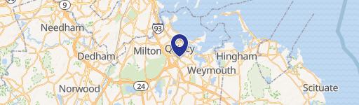
Location Insight
- Map
- Local Demand
- City
- Quincy
- County
- Norfolk
- State
- Massachusetts
- Longitude
- -70.9984
- Latitude
- 42.2494
- CBSA code
- 14460
- CBSA name
- BOSTON-CAMBRIDGE-QUINCY, MA-NH METROPOLITAN STATISTICAL AREA
Property Tax & Assessments
Tax date
Tax Amount
Assessed Land Value
Assessed Improvement Value
Total Assessed Value
Applied Tax Rate
Land Market Value
Improvement Market Value
Total Market Value
2024
$78,054
$1,244,300
$2,232,500
$3,476,800
-
$0.00
$0.00
$0.00