Back to Search
Property profile & analytics
OFF-MARKET
Apartment buildings
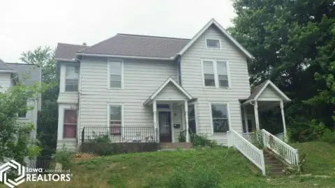
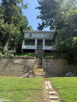
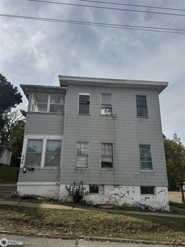
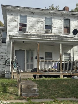
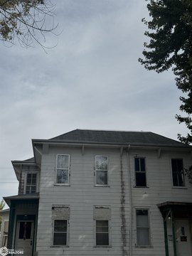
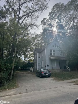
1015 High St Burlington, IA 52601-5048
Entity Owned
4-yr Hold
Absentee Owner
~
Est. High Equity
Property ID
US25-0317992
Property profile
Verified
Property type
Apartment buildings
Use group
APARTMENT HOUSE (5+ UNITS)
Year built
1880
Construction
FRAME
Total area
4,885 SF
Lot
0.24 ac (10,237 SF)
Zoning code
R4
APN
11-32-453-001
UPID
US25-0317992
Cap rate & NOI
Priority signal for investors
Implied cap rate, NOI & suggested price
Cap rate vs submarket · NOI estimate · 3 price anchors
Implied cap rate, NOI & suggested price
Cap vs submarket · NOI estimate · 3 price anchors
Value estimations
Realmo proprietary · 4 methods
AI Approach
AI
by Request
CAP Approach
CAP
by Request
Comparable Approach
Comparable
by Request
Blend (final)
Blend
by Request
Owner & transaction history
K&d Property Management LLC · 4 yrs held
K&d Property Management LLC
since 2021
3 recorded transactions
Zoning & alternative use
R4 · Burlington, IA
Permitted uses
Permitted uses
Allowed · conditional · prohibited
Zoning description
This district is intended to allow for medium and high density neighborhoods by providing varying area requirements
Zone name
Multifamily Residential
General category
RESIDENTIAL
Zone area
701.44 ac
Source
Realmo
Cap rate
Implied · in-place · derived from last sale + estimated NOI
Implied Cap rate
#1
Implied · in-place · NOI ÷ last sale
In-place · derived from last sale + estimated NOI
Cap rate, NOI & submarket benchmark
Implied cap rate vs Burlington submarket · NOI estimate · Typical band, median & reading
Implied cap rate, NOI & submarket benchmark
Cap vs Burlington submarket · NOI estimate · typical band, median & reading
Refine your cap rate
8-question underwriting flow
1.
Property current status — Going-In vs Stabilized
2.
Price for denominator — asking / offer / market
3.
Leasing status & lease structure (NNN / Gross)
4.
Tenant risk profile & vacancy assumption
5.
Upload T12 / rent roll / OM (optional)
Refine in 60 seconds, get exact suggested price
T12 upload · Submarket benchmarks · Sensitivity grid
Suggested price · 3 cap rate anchors
Income approach @ 5% / 7% / 9% — aggressive / typical / conservative
Suggested price at 5% / 7% / 9% cap
Aggressive / typical / conservative · Implied $/SF per anchor · Sensitivity grid
Suggested price at 5% / 7% / 9% cap
Aggressive / typical / conservative · implied $/SF · sensitivity
Value
AI, CAP & Alternative Use estimations · Realmo proprietary blendValue Estimations
Based on Realmo’s proprietary methodology
AI Approach
CAP Approach
Comparable Approach
Alternative Use
Get a detailed, property-specific estimation — fast and free
Price per SF
Sale + rent benchmarks
Subject property
—
Submarket sale & rent benchmarks
Median sale $/SF · Asking & closed rent · Submarket vacancy
Submarket sale & rent benchmarks
Median sale $/SF · asking & closed rent · submarket vacancy
Property tax & assessments
Tax year 2021Property tax & assessments
Tax year 2021
Tax billed
$3,510
Tax year 2021
Assessed value
$200,600
Assessed 2023
Previous assessed
$146,400
+37.0% YoY
Effective rate
1.75%
On assessed value
Assessed land
$10,800
Assessed improvement
$189,800
Land market value
$10,800
Improvement market value
$189,800
Total market value
$200,600
Comparables
6 recent transactions · within 1.5 miComparable in this city
6 recent transactions
Comparable in this City


Similar Nearby for Sale
Similar Nearby for Lease


Recent comparable sales
Sale price & price/SF · Sale date & distance · Adjustments & confidence
Recent comparable sales
Sale price & $/SF · sale date & distance · adjustments
Property description
Physical attributes from public recordsBuilding & lot
Public records
Property type
Apartment buildings
Use group
APARTMENT HOUSE (5+ UNITS)
Status
Off-Market
Year built
1880
Construction
FRAME
Heating
YES
Cooling
NONE
Stories
2
Rooms
14
Bathrooms
2
Total area
4,885 SF
Lot
0.24 ac (10,237 SF)
Zoning code
R4
APN
11-32-453-001
UPID
US25-0317992
Jurisdiction
DES MOINES
Zoning & alternative use
R4 · Burlington, IAZoning R4 · permitted uses
R4 · Burlington, IA
Permitted & conditional uses
Allowed uses · Special-permit conditions · Prohibited uses
Permitted & conditional uses
Allowed · special-permit conditions · prohibited
Zoning description
This district is intended to allow for medium and high density neighborhoods by providing varying area requirements
Zone name
Multifamily Residential
General category
RESIDENTIAL
Zone area
701.44 ac
Source
Realmo
Building & site characteristics
From public records
Year built
1880
Construction
FRAME
Heating
YES
Cooling
Yes
Stories
2
Rooms
14
Bathrooms
2
Lot
0.24 ac
Current owner
From public records · entity-resolved
K&d Property Management LLC
Entity
Mailing address
616 COLUMBIA ST, BURLINGTON, IA 52601-5118
Mailing matches property
Different — outreach signal
Owner-occupied
No
Ownership since
2021
Owner contacts — direct phone, email, and related entities
Decision-maker phone · Verified email · Related entities & filings
Owner contacts
Email · phone · related entities
Sales History
3 recorded events · public records
Date
Price
Buyer
Seller
Deed Type
Mortgage
Oct 13, 2021
—
K&d Property Management LLC
Dustin Evans
Warranty Deed
$180,000 · Two Rivers Bank & Trust
Sep 28, 2021
$230,000
Dustin Evans
Geart River Property Management Co
Warranty Deed
$180,000 · Two Rivers Bank & Trust
Dec 4, 2018
—
Dustin Evans
Great Riv Prop Mgmt Co Lc
Grant Deed
related
—
Coming soon
Costs & Benchmarks
Operating expenses, capex projections, utility benchmarks, and submarket comparables — all in one view.
Coming soon
Risks
Flood, climate, environmental, title, and tenant-concentration risk — surfaced with mitigations and source citations.
Try Rey
Ask anything about this address in plain English.
“Is 15.6% cap rate sustainable?” · “Best tenant mix for BU1?” · “What’s the redev upside?”
You own 1015 High St?
List it free. Reach 20,000 daily buyers.
We’ve already pulled the facts. Confirm photos + price and you’re live in 2 minutes.
List this address →
Full reports are paid
Unlock the full Property Analytics report
Start free for 7 days — no card required. Full owner contacts, all 4 valuations with methodology, refine flow, comparable adjustments, foot-traffic deep dive, export to PDF / CSV.


