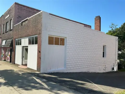
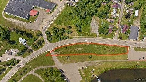
10 Memorial Dr Mayville, NY 14757
Property Lookup
Property profile & analytics
10 Memorial Dr Mayville, NY 14757
- Specialty properties
- 5,941 SF
- 1.72 lot acres
Property ID
US63-2893427
The Realmo ID is a unique identifier assigned to every property, incorporating country codes and precise geo-coordinates for 300x300-foot land blocks. It enables standardized data collection and seamless integration of disparate sources such as ownership, tax, title data and physical specifications. By aggregating current and historical records, the Realmo ID powers advanced analytics and delivers deep, verifiable insights for real estate professionals.
Location Intelligence
Current Use by Public Records
- ScopeChautauqua / Association / Organization
- VFW Post 8647 / Advocacy Group / Social Service Agency
Property Details for 10 Memorial Dr
- Year built
- 1966
- Lot size
- 1.72 lot acres
- Property size
- 5,941 SF
- Zone code
- 04 - FARM
- Property type
- Specialty properties
- APN
- 062801 262.20-1-11
- APU
- 6280126220111
Value Estimations
based on Realmo’s proprietary methodology
-
AI approach
-
CAP approach
-
Comparable approach
-
Alternative Use
Get a detailed, property-specific estimation — fast and free
Location Insight
- Map
- Local Demand
- City
- Mayville
- County
- Chautauqua
- State
- New York
- Longitude
- -79.4937
- Latitude
- 42.2353
- CBSA code
- 27460
- CBSA name
- JAMESTOWN-DUNKIRK-FREDONIA, NY MICROPOLITAN STATISTICAL AREA
Property Tax & Assessments
Tax date
Tax Amount
Assessed Land Value
Assessed Improvement Value
Total Assessed Value
Applied Tax Rate
Land Market Value
Improvement Market Value
Total Market Value
2020
$0.00
$63,800
$186,200
$250,000
-
$74,110
$216,290
$290,400