10 Airport Rd Nantucket, MA 02554-7012
Property profile & analytics
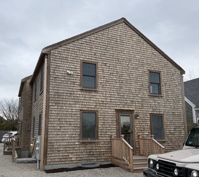
10 Airport Rd, Nantucket, MA 02554-7012
- Commercial real estate
- 0.92 lot acres
Property ID
US38-1631144
The Realmo ID is a unique identifier assigned to every property, incorporating country codes and precise geo-coordinates for 300x300-foot land blocks. It enables standardized data collection and seamless integration of disparate sources such as ownership, tax, title data and physical specifications. By aggregating current and historical records, the Realmo ID powers advanced analytics and delivers deep, verifiable insights for real estate professionals.
Location Intelligence
Current Use by Public Records
- Living Faith Church / Church
- Nantucket Seventh-Day Adventist Church / Church
- ATM (Airport Gas Station) / Atm / Gas And Automotive
- Mobil / Gas Station
Property Details for 10 Airport Rd
- Year built
- 1987
- Lot size
- 0.92 lot acres
- Zone code
- CI
- Property type
- Commercial real estate
- APN
- NANT M:00068 P:00310
- APU
- NANTM00068P00310
Sales History
| Date | Price | Buyer | Seller | Deed Type | Mortgage |
|---|---|---|---|---|---|
| Feb 20, 2013 | — | Airport Gas Station INC | — | Deed Of Trust · related | $520k · Nantucket Savings Bank |
| Jul 12, 2005 | — | Airport Gas Station INC | — | Deed Of Trust · related | $750k · Sovereign Bank |
Value Estimations
based on Realmo’s proprietary methodology
-
AI approach
-
CAP approach
-
Comparable approach
-
Alternative Use
Get a detailed, property-specific estimation — fast and free
Location Insight
- Map
- Local Demand
- City
- Nantucket
- County
- Nantucket
- State
- Massachusetts
- Longitude
- -70.0647
- Latitude
- 41.2596
Property Tax & Assessments
Tax date
Tax Amount
Assessed Land Value
Assessed Improvement Value
Total Assessed Value
Applied Tax Rate
Land Market Value
Improvement Market Value
Total Market Value
2020
$19,242
$1,629,400
$2,406,400
$4,035,800
-
$0.00
$0.00
$0.00