10 Aarons Way West Yarmouth, MA 02673-2594
Property profile & analytics
10 Aarons Way, West Yarmouth, MA 02673-2594
- Commercial land
- 1.13 lot acres
Property ID
US38-0503772
The Realmo ID is a unique identifier assigned to every property, incorporating country codes and precise geo-coordinates for 300x300-foot land blocks. It enables standardized data collection and seamless integration of disparate sources such as ownership, tax, title data and physical specifications. By aggregating current and historical records, the Realmo ID powers advanced analytics and delivers deep, verifiable insights for real estate professionals.
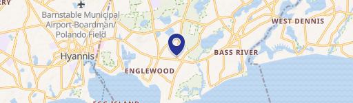
Location Intelligence
Current Use by Public Records
- Commercial land
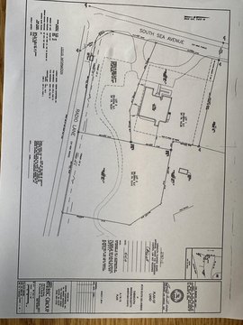
Property Details for 10 Aarons Way
- Lot size
- 1.13 lot acres
- Property type
- Commercial land
- APN
- YARM M:0073 B:9.2.7 L:0000
- APU
- YARMM0073B927L0000
Sales History
| Date | Price | Buyer | Seller | Deed Type | Mortgage |
|---|---|---|---|---|---|
| Dec 30, 2019 | $610,000 | Sunrise Nt | Cape Cod Five Cents Sb | Quit Claim Deed | — |
Value Estimations
based on Realmo’s proprietary methodology
-
AI approach
-
CAP approach
-
Comparable approach
-
Alternative Use
Get a detailed, property-specific estimation — fast and free
Location Insight
- Map
- Local Demand
- City
- West Yarmouth
- County
- Barnstable
- State
- Massachusetts
- Longitude
- -70.2604
- Latitude
- 41.6799
- CBSA code
- 12700
- CBSA name
- BARNSTABLE TOWN, MA METROPOLITAN STATISTICAL AREA
Property Tax & Assessments
Tax date
Tax Amount
Assessed Land Value
Assessed Improvement Value
Total Assessed Value
Applied Tax Rate
Land Market Value
Improvement Market Value
Total Market Value
2024
$3,340
$452,600
$0.00
$452,600
-
$0.00
$0.00
$0.00