T25S Burns Burns, OR 97720
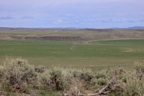
This exceptional 720-acre farm in Harney County, Oregon, presents a unique investment opportunity. Strategically located a quarter-mile from Highway 78, it's just 25 minutes east of Burns and 5 minutes west of Crane, offering access to both communities' amenities. The property boasts 572+ acres under efficient irrigation, utilizing five Reinke pivots powered by four irrigation wells. An "On Trac" radio system monitors the pivots, providing mobile alerts to minimize downtime. Approximately 500+ acres are dedicated to alfalfa, with 250+ acres planted in 2023 and 72+ acres of tritcale planted in fall 2023. The farm consistently yields 2,250 to 2,500 tons of hay annually. Improvements include a metal workshop with a concrete floor, a secure storage container, and a large gravel area for hay storage. The property is fully fenced, enhanced by two additional stock wells. The land includes 146+ acres of pivot corners, roads, and open ground, and approximately 2 acres of improvements and a haystack yard. This property offers a compelling blend of agricultural productivity and convenient access to services and community life in Eastern Oregon. The asking price is $2,225,000. The legal description is T25S R33E W.M. Sec 5 TL 2100, TL1800, TL1700 & T25S R33E W.M. Sec 6 TL2200, Burns, OR 97720.
Cap rate
Implied · in-place · derived from last sale + estimated NOIValue
AI, CAP & Alternative Use estimations · Realmo proprietary blendComparables
6 recent transactions · within 1.5 miComparable in this City


Similar Nearby for Sale


Property description
Physical attributes from public recordsZoning & alternative use
No recorded transactions found for this property.
Costs & Benchmarks
Operating expenses, capex projections, utility benchmarks, and submarket comparables — all in one view.
Risks
Flood, climate, environmental, title, and tenant-concentration risk — surfaced with mitigations and source citations.


