0 State Hwy 60 & County Rd Cedarburg, WI 53012
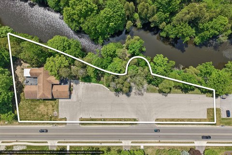
This exceptional 8.69-acre commercial land parcel presents a remarkable redevelopment opportunity in the thriving Cedarburg, Wisconsin market. Strategically located at the hard corner of State Highway 60 and a County Road, this property boasts high visibility and accessibility, making it ideal for a variety of commercial ventures. The site comprises three contiguous parcels (APN: 03-022-01-005.00, 03-022-01-006.00, 03-022-01-007.00), totaling 8.69 acres and zoned B-2 Planned Business District, offering flexibility for diverse development plans. Existing utilities and infrastructure are in place, simplifying the development process and reducing upfront costs. Situated in a highly traveled area between the City of Grafton and the Town of Cedarburg, this location benefits from significant daily traffic volume. Furthermore, its proximity to the I-43 Interchange (3.5 miles) provides easy access to regional transportation networks. The asking price is $2,500,000, translating to $287,687 per acre, reflecting the exceptional value and potential of this prime commercial land. Don't miss this chance to acquire a strategically located, high-traffic property with significant redevelopment potential in a rapidly growing area. The zip code is 53012, and the property is located in Ozaukee County.
Cap rate
Implied · in-place · derived from last sale + estimated NOIValue
AI, CAP & Alternative Use estimations · Realmo proprietary blendComparables
6 recent transactions · within 1.5 miComparable in this City


Similar Nearby for Sale


Similar Nearby for Lease


Property description
Physical attributes from public recordsZoning & alternative use
No recorded transactions found for this property.
Costs & Benchmarks
Operating expenses, capex projections, utility benchmarks, and submarket comparables — all in one view.
Risks
Flood, climate, environmental, title, and tenant-concentration risk — surfaced with mitigations and source citations.


