87 257.8 Acres On Hwy Bolivar Peninsula, TX 77650
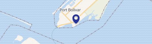
This exceptional 257.8-acre tract of land presents a unique deepwater development opportunity on Highway 87 in Port Bolivar, Texas, zip code 77650. Strategically located with approximately 5,350.3 feet of deepwater frontage on the Bolivar Roads Channel, a natural navigable strait with a depth of 45 feet (14 meters), this site offers significant advantages over locations further inland on the Houston Ship Channel. Estimated vessel transport time reductions of up to six hours in each direction translate to substantial demurrage cost savings. The property's proximity to existing pipelines, including potential connections to the Speed Junction and Nederland Pipelines, further enhances its appeal. The site is suitable for a 3 million barrel bulk storage facility, marine terminal, and associated docking, port, and off-take infrastructure. The land is comprised of several parcels, including approximately 52 acres, 92 acres, 101 acres, and 12.8 acres, along with 72 acres of upland area. Access is readily available via I-10 East through High Island and I-45 South via the Bolivar Ferry. Essential utilities, including electricity and water/sewer, are available. The property is located within Galveston County and the Galveston ISD taxing districts. This location offers a compelling investment opportunity for mid-stream energy operations seeking a strategic "blue water" site with significant cost and time advantages.
Cap rate
Implied · in-place · derived from last sale + estimated NOIValue
AI, CAP & Alternative Use estimations · Realmo proprietary blendComparables
6 recent transactions · within 1.5 miComparable in this City


Similar Nearby for Sale


Property description
Physical attributes from public recordsZoning & alternative use
No recorded transactions found for this property.
Costs & Benchmarks
Operating expenses, capex projections, utility benchmarks, and submarket comparables — all in one view.
Risks
Flood, climate, environmental, title, and tenant-concentration risk — surfaced with mitigations and source citations.


