60 At Flt Powhatan, VA 23139
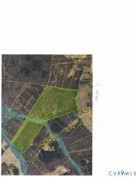
This exceptional 31.2-acre commercial land parcel presents a significant investment opportunity in Powhatan, Virginia. Strategically located on Route 60 at Flat Rock, this property boasts 734 feet of frontage on Anderson Highway, enhanced by a median cut on both sides, ensuring exceptional visibility and accessibility for any commercial venture. The property is zoned C and features two parcel identification numbers: #041-12A and #041-6C. Water is available on-site. This location is designated as a Gateway Business in the Powhatan Comprehensive Plan, placing it in a prime position for development. Its convenient location midway between Westchester Commons and Route 522, and directly across from Wilton Square at Flatrock, provides immediate access to a thriving commercial area. Nearby established retailers include Dunkin' Donuts, McDonald's, Tractor Supply, and Sheetz, further highlighting the area's strong commercial activity. The high traffic volume exceeding 25,000 vehicles per day ensures significant exposure for any business established on this property. This is a rare opportunity to acquire a substantial commercial land holding in a high-growth area with excellent visibility and access. The asking price for this remarkable property is $1,399,000. The property's zip code is 23139.
Cap rate
Implied · in-place · derived from last sale + estimated NOIValue
AI, CAP & Alternative Use estimations · Realmo proprietary blendComparables
6 recent transactions · within 1.5 miComparable in this City


Similar Nearby for Sale


Similar Nearby for Lease


Property description
Physical attributes from public recordsZoning & alternative use
No recorded transactions found for this property.
Costs & Benchmarks
Operating expenses, capex projections, utility benchmarks, and submarket comparables — all in one view.
Risks
Flood, climate, environmental, title, and tenant-concentration risk — surfaced with mitigations and source citations.


