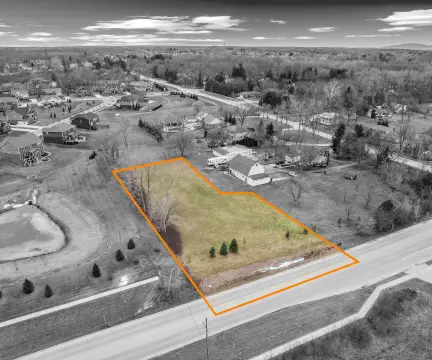
0 6.55 Acres – Frd Rd Canton, MI 48187
This exceptional 6.55-acre commercial land parcel presents a unique development opportunity in Canton, Michigan. Located on Ford Road, this property boasts significant main road frontage, providing excellent visibility and accessibility. Currently zoned R-1 (Residential), the uniquely shaped site offers numerous development options for discerning investors. The asking price is $475,000, translating to $72,520 per acre. The property's location in Wayne County, with a zip code of 48187, places it within a thriving community. Its coordinates are 42.3220683 latitude and -83.4832957 longitude. The parcel's APN is #71-069-99-0005-001. This prime location and flexible zoning make it ideal for a variety of commercial ventures, offering significant potential for future growth and return on investment. Serious inquiries are encouraged to explore the possibilities this remarkable property offers. The land's unique shape allows for creative development plans, maximizing its potential value. This is a rare opportunity to acquire a substantial land holding in a desirable location with excellent road frontage.
Cap rate
Implied · in-place · derived from last sale + estimated NOIValue
AI, CAP & Alternative Use estimations · Realmo proprietary blendComparables
6 recent transactions · within 1.5 miComparable in this City


Similar Nearby for Sale


Similar Nearby for Lease


Property description
Physical attributes from public recordsZoning & alternative use
No recorded transactions found for this property.
Costs & Benchmarks
Operating expenses, capex projections, utility benchmarks, and submarket comparables — all in one view.
Risks
Flood, climate, environmental, title, and tenant-concentration risk — surfaced with mitigations and source citations.


