0 Highway 54 Fayetteville, GA 30215
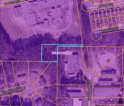
This 13.32-acre commercial land parcel presents a significant development opportunity in Fayetteville, Georgia. Located on Hwy 54 W in Fayette County (zip code 30215), this property boasts a high-traffic location with 45,800 vehicles passing daily at the intersection of GA Hwy 54 (34,300 VPD) and Tyrone Rd (11,500 VPD). Currently zoned MHP (Mobile Home Park), the site's highest and best use is commercial or retail development. Fayette County is receptive to rezoning applications for commercial use. The property's history includes operation as Adams Farm, a popular local produce stand. Prospective buyers should note the absence of on-site sewer; connection may require future development or holding the property until sewer access becomes available. This exceptional location and substantial acreage offer significant potential for a variety of commercial ventures. The property's latitude and longitude coordinates are 33.44472591929563 and -84.52639655902063 respectively. This is a rare opportunity to acquire a large tract of land in a rapidly growing area.
Cap rate
Implied · in-place · derived from last sale + estimated NOIValue
AI, CAP & Alternative Use estimations · Realmo proprietary blendComparables
6 recent transactions · within 1.5 miComparable in this City


Similar Nearby for Sale


Property description
Physical attributes from public recordsZoning & alternative use
No recorded transactions found for this property.
Costs & Benchmarks
Operating expenses, capex projections, utility benchmarks, and submarket comparables — all in one view.
Risks
Flood, climate, environmental, title, and tenant-concentration risk — surfaced with mitigations and source citations.


