Property summary
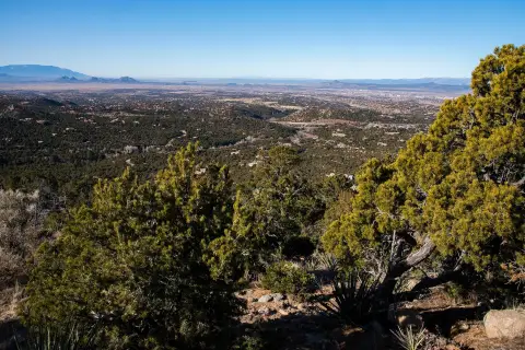
This exceptional 6,421-acre property in Santa Fe County, New Mexico, presents a significant development opportunity. Strategically located along Interstate 25 between Albuquerque and Santa Fe, this expansive land parcel boasts over 10,000 feet of I-25 frontage, accessible via two major interchanges. Exit 264 (State Highway 16) connects to the Cochiti Indian Reservation and Santo Domingo Pueblo, while Exit 267 (County Road 57) links to Highway 14 and the Madrid/Cerrillos Mountains. The property is conveniently situated approximately 35 minutes from Albuquerque International Sunport and 15 minutes from Santa Fe Plaza. Approximately 5,200 acres contain rich aggregate deposits suitable for mining. The land's high elevation (over 6,100 feet) offers varied scenic views, including the Santa Fe National Forest and several mountain ranges. The area's rich mining and railroad history is evident in existing mines and the main rail line running through the property, including a Rail Runner spur. This unique location, coupled with its substantial size and access to major transportation routes, makes it ideal for a variety of development projects, including residential master planning and aggregate resource extraction. Approximately 10,000 acres are currently under contract for renewable energy development. The land is priced at $3,000 per acre.
Property profile
VerifiedCap rate & NOI
Location
Value estimations
Owner & transaction history
Comparables
6 recent transactions · within 1.5 miComparable in this City


Similar Nearby for Sale



Similar Nearby for Lease



Value estimation
Instant AI valuation built from comps, income signals, and proprietary benchmarks. A defensible range, not a single guess.
from $99/month
Cap rate
Cap rate calculated from real income and expense signals, benchmarked against sales of similar assets nearby.
from $99/month
Property description
Physical attributes from public recordsZoning & alternative use
Zoning
The recorded zoning designation, what the district officially allows, and the municipal source it comes from.
No zoning code is on file for this parcel. Zoning coverage grows with every catalog release — check back, or open Location Intelligence for use analysis of this corner.
Find the owner behind the property.
Unlock the evidence behind ownership: portfolio, transactions, debt and signals that help you decide who to contact next.
Registration is required before any owner information is shown.
- Full Property Data
- Historical Records
- Value Estimation
- NOI Potential
- Cap Rate Calculation
- Ownership
- Location Insight
- Alternative use
- Local Zoning Insight
Cancel anytime.
- 30 reports a month
- Location Analytics
- Market Trends
- Full Property Data
- Historical Records
- Value Estimation
- NOI Potential
- Cap Rate Calculation
- Ownership
- Location Insight
- Alternative use
- Local Zoning Insight
Cancel anytime.
- 300 reports a month
- Location Analytics
- Market Trends
- Full Property Data
- Historical Records
- Value Estimation
- NOI Potential
- Cap Rate Calculation
- Ownership
- Location Insight
- Alternative use
- Local Zoning Insight
and get 1 Light Report
- Property Information
- Historical Records
- Value Estimation
- NOI Potential
- Cap Rate Potential
- Location Insight
- Alternative use
- Local Zoning Insight


