Property summary
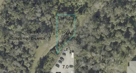
This exceptional 4.48-acre commercial land parcel presents a remarkable investment opportunity in the thriving Sanford, Florida market. Strategically located at the intersection of State Road 46 and N White Cedar Road, this property boasts high visibility and accessibility, benefiting from a significant average annual daily traffic count of 35,000 vehicles on SR 46. The land is fully usable, with offsite retention already in place and utilities conveniently stubbed to each property line, simplifying development and reducing upfront costs. Zoned for commercial use, this site is ideally suited for a variety of development projects, catering to the area's robust commercial growth. The surrounding area exhibits strong residential growth, further enhancing the property's long-term potential. With an average household income of $94,000, the demographic profile supports a diverse range of commercial ventures. Located in Seminole County, Florida, and easily accessible via State Road 46, this property offers unparalleled convenience and exposure. The 32771 zip code further underscores the property's prime location within a dynamic and expanding market. This is a rare opportunity to acquire a significant commercial land parcel in a high-growth area with excellent infrastructure and strong market fundamentals. Don't miss this chance to capitalize on the burgeoning Sanford commercial real estate market.
Property profile
VerifiedCap rate & NOI
Location
Value estimations
Owner & transaction history
Comparables
6 recent transactions · within 1.5 miComparable in this City


Similar Nearby for Sale


Similar Nearby for Lease


Value estimation
Instant AI valuation built from comps, income signals, and proprietary benchmarks. A defensible range, not a single guess.
from $99/month
Cap rate
Cap rate calculated from real income and expense signals, benchmarked against sales of similar assets nearby.
from $99/month
Property description
Physical attributes from public recordsZoning & alternative use
Zoning
The recorded zoning designation, what the district officially allows, and the municipal source it comes from.
No zoning code is on file for this parcel. Zoning coverage grows with every catalog release — check back, or open Location Intelligence for use analysis of this corner.
Find the owner behind the property.
Unlock the evidence behind ownership: portfolio, transactions, debt and signals that help you decide who to contact next.
Registration is required before any owner information is shown.
- Full Property Data
- Historical Records
- Value Estimation
- NOI Potential
- Cap Rate Calculation
- Ownership
- Location Insight
- Alternative use
- Local Zoning Insight
Cancel anytime.
- 30 reports a month
- Location Analytics
- Market Trends
- Full Property Data
- Historical Records
- Value Estimation
- NOI Potential
- Cap Rate Calculation
- Ownership
- Location Insight
- Alternative use
- Local Zoning Insight
Cancel anytime.
- 300 reports a month
- Location Analytics
- Market Trends
- Full Property Data
- Historical Records
- Value Estimation
- NOI Potential
- Cap Rate Calculation
- Ownership
- Location Insight
- Alternative use
- Local Zoning Insight
and get 1 Light Report
- Property Information
- Historical Records
- Value Estimation
- NOI Potential
- Cap Rate Potential
- Location Insight
- Alternative use
- Local Zoning Insight


