Development Land with Scenic
Spalding Road, Whitesboro, TX 76273
- Added:
- Feb 10, 2026
- Days on Market:
- 113
- Last Refresh:
- Jun 3 at 12:06 am
Property Features for Spalding Road
General Information
- Property type
- Land
- Property subtype
- Other
- Standard status
- Active
- APN
- 120559
- Lot size
- 213.32 Acres
Taxes and HOA fees
- Tax Description
- G-0565 HARSHBARGER THOMAS A-G0565, ACRES 55.5
- Tax Annual Amount
- 32
Listing agent JON SANDERS License #0501531 (903) 564-3426
Listing office SANDERS REAL ESTATE Whitesboro, TX (903) 564-3426
Listing date Feb 10, 2026
MLS# 20956345
Listing URL
Copyright © 2026 North Texas Real Estate Information Systems, Inc. All rights reserved. All information provided by the listing agent/broker is deemed reliable but is not guaranteed and should be independently verified.
HighLights
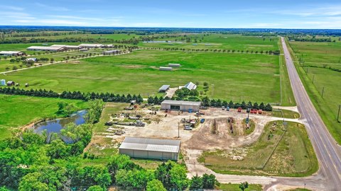
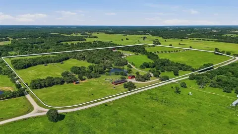
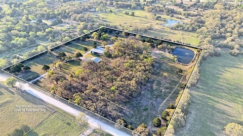
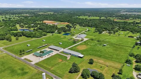
- 213.32‑acre purposed development land on Spalding Rd in Sherman, TX
- Ag exemption in place and access to co‑op utilities at the road frontage
- Located about 1 mile west of the proposed Grayson County Toll Way (Dallas North Toll Way Expansion)
- Approximately 12 miles west of Sherman and 7 miles east of Whitesboro
- Rolling hills and lush meadows with long‑range views in all directions
Overview
Introducing Prairie View Estates, a 213.32-acre property presented as a purposed development site on Spalding Rd. The land offers rolling hills and lush meadows with expansive views in multiple directions. An ag exemption is in place, and the property has access to co-op utilities at the road frontage.
The tract is positioned in Grayson County, approximately one mile west of the proposed Grayson County Toll Way (Dallas North Toll Way Expansion). It is described as 12 miles west of Sherman and 7 miles east of Whitesboro, placing it within reach of ongoing commercial and industrial growth in the wider area.
For buyers and developers, the combination of substantial acreage, road frontage utility access, and existing ag exemption makes this a practical platform for planning a long-term project footprint. The scenic topography and broad sightlines can also support a variety of development concepts where open, rural character is a desired element.
Location Intelligence
Current Use by Public Records
Industrial land
Map
- City
- Whitesboro
- County
- Grayson
- State
- Texas
- Longitude
- -96.8117098
- Latitude
- 33.6589609
Nearby Similar for Sale

FAQs
What type of property is this?
Industrial land - A large acreage tract with road-front utility access and an existing ag exemption, well-suited for future development planning.
Where is this industrial land located?
The property is located at Spalding Road Whitesboro, TX.
What is the asking price?
The asking price for this property is $8,450,000.
What are key features of this property?
This property features: 213.32‑acre purposed development land on Spalding Rd in Sherman, TX; Ag exemption in place and access to co‑op utilities at the road frontage; Located about 1 mile west of the proposed Grayson County Toll Way (Dallas North Toll Way Expansion)


