Rural Land
0 S 539th +/- Avenue Parcel 5, Tonopah, AZ 85354
For Sale
Contact for pricing
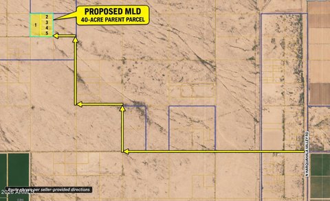
RU-43-zoned land in Tonopah is part of a proposed minor land division.
Property SizeContact for details
Days on Market14
Property Features for 0 S 539th +/- Avenue Parcel 5
General Information
Standard status
Property subtype
Listing Agency:
HomeSmart
(602) 230-7600
Listed By:
Jose G Reyes · License AZ SA554116000
(602) 290-4747
Source:
Mariannashone
Added: Nov 8
Changed: Nov 13
Last Checked: Nov 20 at 9:43PM
Displayed information is deemed reliable but is not guaranteed and should be independently verified. All listing content including descriptions, pricing, images are the copyrighted material of HomeSmart

Ask AI about this property
Review the available facts, identify missing information and prepare questions for the agent.
Investment Insights
Based on property information with market context.
This approximately 5-acre parcel in Tonopah is described as flat and level and carries RU-43 zoning. It is Parcel 5 of a proposed minor land division from parent APN 506-22-068; the division is to be completed before escrow closes. No power is nearby.
The property is near Buckeye and about 15 minutes from I-10. Its location is identified by GPS coordinates 33.484541, -113.211745.
The property is near Buckeye and about 15 minutes from I-10. Its location is identified by GPS coordinates 33.484541, -113.211745.
Key Highlights
- Approximately 5 acres of flat, level land
- RU‑43 zoning
- Parcel 5 in a proposed minor land division; completion is planned before close of escrow
Location Intelligence
Trade Area within ½ mile
Improve property use
Find place for business
Demographics for 85354, AZ
7,200
Population
3,024
Households
2.4
Avg Household Size
39
Median Age
10%
College-Educated
79%
High-School Grad
715.7 sq mi
ZIP Area
10
Density / Sq Mi
Median Household Income
Median Earnings
Median Rent
Median Home Value
Market
Properties on Market for Land in Tonopah




Frequently Asked Questions
What type of property is this?
Land - RU-43-zoned land in Tonopah is part of a proposed minor land division.
Where is this land located?
The property is located at 0 S 539th +/- Avenue Parcel 5 Tonopah, AZ.
What are key features of this property?
This property features: Approximately 5 acres of flat, level land; RU‑43 zoning; Parcel 5 in a proposed minor land division; completion is planned before close of escrow