Northwest Missouri Farmland with Grain
New
For Sale
$345,000
North side of Iris Trail, Barnard, MO 64423
LAND - Barnard, MO
Property SizeContact for details
Lot Size69.00 Acres
Days on Market6
Property Features for North side of Iris Trail
General Information
Property type
Land
Property subtype
Other
Directions
Land is located just west of US 71 Highway on Iris Road, North of the Andrew/Nodaway County Line.
Standard status
Active
Lot size
69.00 Acres
Listing Agency:
West Central Auction Co.
(816) 884-1987
Listed By:
Jeffrey S Pittman
(816) 884-1987
Added: Aug 6
Last Checked: Aug 11 at 5:06PM
MLS# 11922534
Copyright © 2026 My State MLS. All rights reserved. All information provided by the listing agent/broker is deemed reliable but is not guaranteed and should be independently verified.
Investment Insights
Based on property information with market context.
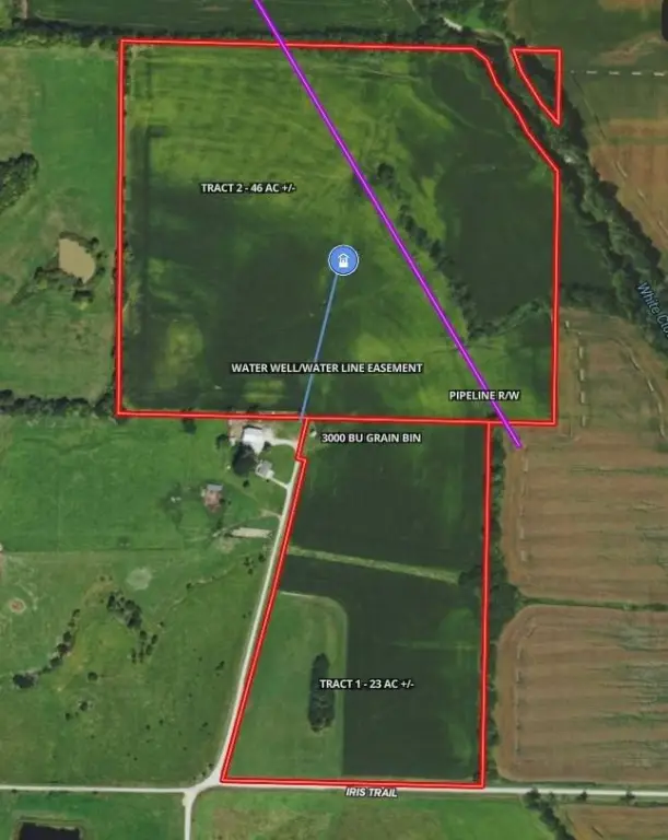
This agricultural property encompasses approximately 69 taxable acres in Nodaway County, including 64.78 FSA cropland acres arranged in well-configured fields. Soil types include Zook and Sharpsburg silty clay loams, with an overall 75.4 NCCPI rating. A 3,000-bushel grain bin adds on-site storage capacity for farming operations.
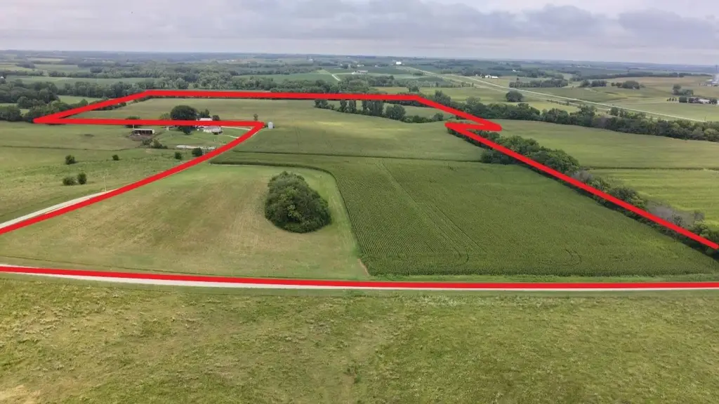
The farm fronts Iris Trail on the north side and lies approximately 0.3 mile west of U.S. Highway 71, with access suited to agricultural equipment. It is located approximately 15 miles south of Maryville, Missouri, in the White Cloud Bottom area. Active USDA conservation practices are in place. The property is subject to a water well/waterline easement and a pipeline right-of-way, both transferring with the land.
The acreage may be acquired as separate tracts of approximately 23 acres and 46 acres, or together as the full property. The 2026 crop season is currently leased, with possession subject to applicable farm tenancy or lease agreements.
The farm fronts Iris Trail on the north side and lies approximately 0.3 mile west of U.S. Highway 71, with access suited to agricultural equipment. It is located approximately 15 miles south of Maryville, Missouri, in the White Cloud Bottom area. Active USDA conservation practices are in place. The property is subject to a water well/waterline easement and a pipeline right-of-way, both transferring with the land.
The acreage may be acquired as separate tracts of approximately 23 acres and 46 acres, or together as the full property. The 2026 crop season is currently leased, with possession subject to applicable farm tenancy or lease agreements.
Key Highlights
- Approximately 69 taxable total acres
- 64.78 FSA cropland acres
- Overall 75.4 NCCPI with Zook and Sharpsburg silty clay loam soils
Property Analytics
Current Use
Location Intelligence
Trade Area within ½ mile
1
Businesses Nearby
Explore this area
Business Placement
Demographics for 64423, MO
760
Population
407
Households
1.9
Avg Household Size
41
Median Age
14%
College-Educated
97%
High-School Grad
71.9 sq mi
ZIP Area
11
Density / Sq Mi
$65,000
Median Household Income
$45,804
Median Earnings
$148,400
Median Home Value

Questions? Ask Rey
Realmo’s AI knows this listing — price, zoning, demand, history. Ask anything.
Frequently Asked Questions
What type of property is this?
Agricultural land / Farmland - Agricultural acreage offers cultivated fields, on-site grain storage, and access from Iris Trail near U.S. Highway 71.
Where is this agricultural land / farmland located?
The property is located at North side of Iris Trail Barnard, MO.
What is the asking price?
The asking price for this property is $345,000.
What are key features of this property?
This property features: Approximately 69 taxable total acres; 64.78 FSA cropland acres; Overall 75.4 NCCPI with Zook and Sharpsburg silty clay loam soils


