Recreational Land with Road
800 East 800th Street South Fillmore, UT 84631
For Sale
$165,000
Roughly 5-acre recreational parcel with dirt-road access, easement access, and valley-and-mountain views.
Property Size219,978 SF
Lot Size5.00 Acres
Price / SF$0.75
Days on Market336
Property Features for 800 East 800th Street South
General Information
- Standard status
- Active
- Size
- 219,978 SF
- Lot size
- 5.00 Acres
- Property subtype
- Land / Recreational
Listing Agency:
Signature Real Estate Services
(435) 253-1138
Listed By:
Lucas Stevens · License #7551924
(435) 253-1138
Source:
Compass
Added: Aug 26, 2025
Changed: Jul 10
Last Checked: Jul 26 at 1:24PM
Displayed information is deemed reliable but is not guaranteed and should be independently verified. All listing content including descriptions, pricing, images are the copyrighted material of Signature Real Estate Services
Investment Insights
Based on property information with market context.
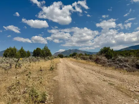
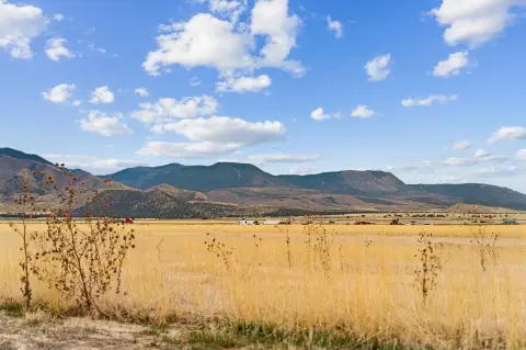
This offering is a recreational land parcel of approximately 5 acres, positioned on one of the higher points on the hill in the “June Brush” area. The property is described as supporting year-round outdoor use and wildlife activity, with deer, turkeys, and other wildlife referenced in the remarks. The site also offers valley views to the west and mountain views to the east.
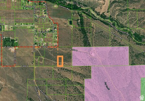
Access is described via a 66-foot dirt road access and a 30-foot easement to the acreage. Directions from 700 East in Fillmore call for heading south on Sand Rock Ridge Road to 700 South, just on the south side of the homes. The address and maps are approximate, and the red dashed line in the pictures indicates the Fillmore City limits.
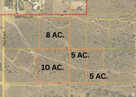
For buyers looking to own land for hunting and recreation, this parcel offers a manageable size with straightforward access details included in the listing. If development for water access is part of the plan, the remarks note underground water rights are available to purchase for $20,000 per acre foot. Additional parcels are also available next to this one for users seeking a larger land investment.
Access is described via a 66-foot dirt road access and a 30-foot easement to the acreage. Directions from 700 East in Fillmore call for heading south on Sand Rock Ridge Road to 700 South, just on the south side of the homes. The address and maps are approximate, and the red dashed line in the pictures indicates the Fillmore City limits.
For buyers looking to own land for hunting and recreation, this parcel offers a manageable size with straightforward access details included in the listing. If development for water access is part of the plan, the remarks note underground water rights are available to purchase for $20,000 per acre foot. Additional parcels are also available next to this one for users seeking a larger land investment.
Key Highlights
- Approximately 5‑acre recreational parcel in the “June Brush” area on the outskirts of Fillmore
- Valley views to the west and mountain views to the east, located at one of the highest points on the hill
- 66' dirt road access plus a 30' easement providing access to the 5 acres
Property Analytics
Property Profile
Location Intelligence
Current Use by Public Records
Hunting land


FAQs
What type of property is this?
Hunting land - Roughly 5-acre recreational parcel with dirt-road access, easement access, and valley-and-mountain views.
Where is this hunting land located?
The property is located at 800 East 800th Street South Fillmore, UT.
What is the asking price?
The asking price for this property is $165,000.
What are key features of this property?
This property features: Approximately 5‑acre recreational parcel in the “June Brush” area on the outskirts of Fillmore; Valley views to the west and mountain views to the east, located at one of the highest points on the hill; 66' dirt road access plus a 30' easement providing access to the 5 acres


