Riverfront Land with 160'
5220 Fort Denaud Rd Labelle, FL 33935
For Sale
$750,000
High-and-dry Caloosahatchee River land with extensive frontage, protected views, and an elevated homesite for private estate planning.
Lot Size3.00 Acres
Days on Market55
Property Features for 5220 Fort Denaud Rd
General Information
- Standard status
- Active
- Lot size
- 3.00 Acres
- Property subtype
- Land
Listing Agency:
Southern Heritage Real Estate
(239) 634-6525
Listed By:
K.C. Stanley Lynn · License #258000253
(239) 634-6525
Source:
Elliman
Added: Jun 1
Changed: Jul 10
Last Checked: Jul 25 at 6:25AM
Displayed information is deemed reliable but is not guaranteed and should be independently verified. All listing content including descriptions, pricing, images are the copyrighted material of Southern Heritage Real Estate
Investment Insights
Based on property information with market context.
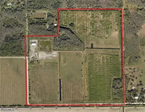
This riverfront property offers approximately 3± acres with about 160 feet of frontage on the Caloosahatchee River, part of the Intracoastal Waterway. The site is described as high and dry, with an elevated homesite and panoramic water views. Mature trees remain on the land, and the acreage has been underbrushed to preserve natural privacy and an old-Florida setting. Fencing and outbuildings are indicated as permitted subject to zoning requirements. The property will require installation of a well and septic system.
The land fronts Ft. Denaud Road and is located about one-half mile from State Road 80. The location is also stated to be approximately 4 miles from the Lee/Hendry County line. The view across the river is described as protected by a 300± acre orange grove rather than neighboring homes.
This is a practical fit for buyers seeking a secluded riverfront homesite with room for recreational flexibility, including space to bring an RV or boat, subject to zoning and permitting. With no HOA fees and no deed restrictions noted, the property is positioned for buyers who want to plan their own improvements, including potential permitting for a slope to the riverbank or a dock through Hendry County and the US Army Corp of Engineers.
Key Highlights
- 3+ acre Caloosahatchee Riverfront property with approximately 160 ft of river frontage on the Intracoastal Waterway
- High‑and‑dry river views with no flood insurance required
- View across the river is protected by a sprawling 300+ acre orange grove rather than neighboring homes
Property Analytics
Property Profile
Location Intelligence
Current Use by Public Records
Waterfront Land


FAQs
What type of property is this?
Waterfront Land - High-and-dry Caloosahatchee River land with extensive frontage, protected views, and an elevated homesite for private estate planning.
Where is this waterfront land located?
The property is located at 5220 Fort Denaud Rd Labelle, FL.
What is the asking price?
The asking price for this property is $750,000.
What are key features of this property?
This property features: 3+ acre Caloosahatchee Riverfront property with approximately 160 ft of river frontage on the Intracoastal Waterway; High‑and‑dry river views with no flood insurance required; View across the river is protected by a sprawling 300+ acre orange grove rather than neighboring homes