12-15S-20W 12-15S-20W Magnolia, AR 71753
- Added:
- Apr 7, 2026
- Days on Market:
- 32
- Last Refresh:
- May 8 at 12:06 pm
Property Features for 12-15S-20W 12-15S-20W
General Information
- Property type
- Land
- Property subtype
- Other
- Standard status
- Active
- Lot size
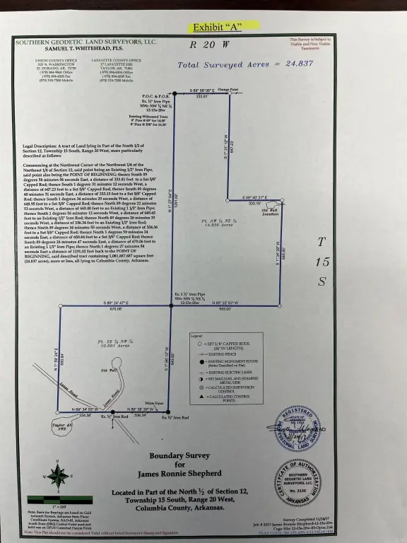
- 24.83 Acres
Taxes and HOA fees
- Tax Annual Amount
- 29
Building Details
- Architectural style
- Other
Listing agent C.Ryan Jackson (870) 310-1411
Listing office Stevens Forestry Service, Inc. 100 West Sharp, El Dorado, AR (870) 863-5068
Listing date Apr 7, 2026
MLS# 26015597
Listing URL
Copyright © 2026 Cooperative Arkansas Realtors Multiple Listing Service. All rights reserved. All information provided by the listing agent/broker is deemed reliable but is not guaranteed and should be independently verified.
HighLights
- Well‑stocked stand of pine & hardwood offering potential for immediate returns.
- Soil types are fine sandy loams suitable for loblolly pine with a site index of 84 feet.
- Gently rolling and well‑drained topography.
- Located approximately 4 miles northwest of the Stephens community.
- Access via an improved oil field road.
- Coordinates provided for precise location: [-93.1262,33.44849].
Overview
Magnolia, AR Acreage For Sale
Located approximately 4 miles northwest of the Stephens community, this 24.83-acre tract is accessible via an improved oil field road that traverses the southwest corner. The topography is gently rolling and well-drained. The soil types are fine sandy loams, with an average site index for loblolly pine of 84 feet (base age 50) according to the NRCS web soil survey. The property contains a well-stocked stand of pine and hardwood, offering the potential for immediate returns.
Location Intelligence
Current Use by Public Records
Agricultural land / Farmland
Map
- City
- Magnolia
- County
- Columbia
- State
- Arkansas
- Longitude
- -93.2572
- Latitude
- 33.2253
Nearby Similar for Sale


FAQs
What type of property is this?
Agricultural land / Farmland - 24.83 acres of pine and hardwood near Stephens, Arkansas.
Where is this agricultural land / farmland located?
The property is located at 12-15S-20W 12-15S-20W Magnolia, AR.
What is the asking price?
The asking price for this property is $57,500.
What are key features of this property?
This property features: Well‑stocked stand of pine & hardwood offering potential for immediate returns.; Soil types are fine sandy loams suitable for loblolly pine with a site index of 84 feet.; Gently rolling and well‑drained topography.


