Rte 315 Pittston, PA 18640
Property profile & analytics
Rte 315, Pittston, PA 18640
- Commercial real estate
- 1.18 lot acres
Property ID
US73-4138021
The Realmo ID is a unique identifier assigned to every property, incorporating country codes and precise geo-coordinates for 300x300-foot land blocks. It enables standardized data collection and seamless integration of disparate sources such as ownership, tax, title data and physical specifications. By aggregating current and historical records, the Realmo ID powers advanced analytics and delivers deep, verifiable insights for real estate professionals.
Location Intelligence
Current Use by Public Records
- Commercial real estate
Property Details for Rte 315
- Lot size
- 1.18 lot acres
- Property type
- Commercial real estate
- APN
- 51-E12S3-003-06A
- APU
- 51E12S300306A
Sales History
| Date | Price | Buyer | Seller | Deed Type | Mortgage |
|---|---|---|---|---|---|
| Jul 31, 2020 | — | Saypa LLC | — | Deed · related | $1M · Wells Fargo Bk |
| Apr 2, 2013 | — | Saypa LLC | — | Grant Deed · related | $1M · Wells Fargo Bk |
| Jan 28, 2011 | $250,000 | Pittston 315 Properties LLC | Highway 315 Properties INC | Grant Deed | — |
| — | — | Saypa LLC | — | Loan Modification · related | $1M · Wells Fargo Bk |
| — | — | Mohebac Real Estate LLC | — | Deed Of Trust · related | $1M · Omni National Bank |
Value Estimations
based on Realmo’s proprietary methodology
-
AI approach
-
CAP approach
-
Comparable approach
-
Alternative Use
Get a detailed, property-specific estimation — fast and free
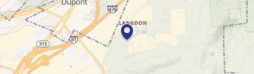
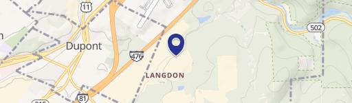
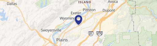
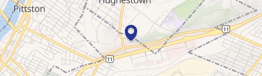
Location Insight
- Map
- Local Demand
- City
- Pittston
- County
- Luzerne
- State
- Pennsylvania
- Longitude
- -75.7624
- Latitude
- 41.3074
- CBSA code
- 42540
- CBSA name
- SCRANTON--WILKES-BARRE, PA METROPOLITAN STATISTICAL AREA
Property Tax & Assessments
Tax date
Tax Amount
Assessed Land Value
Assessed Improvement Value
Total Assessed Value
Applied Tax Rate
Land Market Value
Improvement Market Value
Total Market Value
2023
$864
$35,400
$0.00
$35,400
-
$35,400
$0.00
$35,400