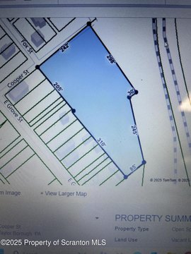
Rd A Parcel Taylor, PA 18517
Property profile & analytics
Rd A Parcel, Taylor, PA 18517
- Industrial properties
- 26.83 lot acres
Property ID
US73-4254395
The Realmo ID is a unique identifier assigned to every property, incorporating country codes and precise geo-coordinates for 300x300-foot land blocks. It enables standardized data collection and seamless integration of disparate sources such as ownership, tax, title data and physical specifications. By aggregating current and historical records, the Realmo ID powers advanced analytics and delivers deep, verifiable insights for real estate professionals.
Location Intelligence
Current Use by Public Records
- Industrial properties
Property Details for Rd A Parcel
- Lot size
- 26.83 lot acres
- Property type
- Industrial properties
- APN
- 15507010013
- APU
- 15507010013
Sales History
| Date | Price | Buyer | Seller | Deed Type | Mortgage |
|---|---|---|---|---|---|
| Nov 5, 2020 | — | Stauffer Industrial Owner LP | Kane Properties I LP | Grant Deed | — |
| Jun 11, 2014 | $39,000,000 | Pa14 Taylor LLC | Kane Properties I LP | Special Warranty Deed | $22.6M · Prudential Mortgage Capital Company |
| May 30, 2007 | — | Props I Kane | Owner,record | Grant Deed · related | — |
Value Estimations
based on Realmo’s proprietary methodology
-
AI approach
- Method
- Estimation
- Statistic approach
- $32,955,000
Get a detailed, property-specific estimation — fast and free
Location Insight
- Map
- Local Demand
- City
- Taylor
- County
- Lackawanna
- State
- Pennsylvania
- Longitude
- -75.7
- Latitude
- 41.4082
- CBSA code
- 42540
- CBSA name
- SCRANTON--WILKES-BARRE, PA METROPOLITAN STATISTICAL AREA
Property Tax & Assessments
Tax date
Tax Amount
Assessed Land Value
Assessed Improvement Value
Total Assessed Value
Applied Tax Rate
Land Market Value
Improvement Market Value
Total Market Value
2024
$147,095
$70,550
$613,774
$684,324
-
$70,550
$613,774
$684,324