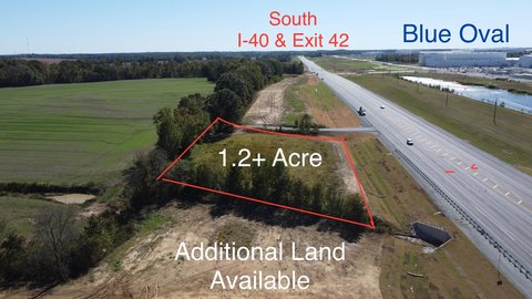
Hwy 76 Stanton, TN 38069
Property profile & analytics
Hwy 76, Stanton, TN 38069
- Commercial land
- 1.90 lot acres
Property ID
US80-2458010
The Realmo ID is a unique identifier assigned to every property, incorporating country codes and precise geo-coordinates for 300x300-foot land blocks. It enables standardized data collection and seamless integration of disparate sources such as ownership, tax, title data and physical specifications. By aggregating current and historical records, the Realmo ID powers advanced analytics and delivers deep, verifiable insights for real estate professionals.
Location Intelligence
Current Use by Public Records
- Commercial land
Property Details for Hwy 76
- Lot size
- 1.90 lot acres
- Zone code
- FAR
- Property type
- Commercial land
- APN
- 122 02300
- APU
- 12202300
Sales History
| Date | Price | Buyer | Seller | Deed Type | Mortgage |
|---|---|---|---|---|---|
| May 12, 2005 | $41,000 | Jesse Cannon | Exit 52 Flea Market LLC | Warranty Deed | $37k · Charles T Clark |
| Feb 25, 2004 | $37,936 | Exit 52 Flea Market LLC | Mazyck,joel L | Warranty Deed | — |
| Nov 22, 1994 | $4,400 | Joel Mazuck | — | Grant Deed · related | — |
Value Estimations
based on Realmo’s proprietary methodology
-
AI approach
-
CAP approach
-
Comparable approach
-
Alternative Use
Get a detailed, property-specific estimation — fast and free
Location Insight
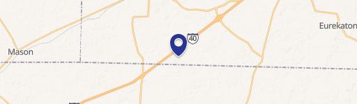
- Map
- Local Demand
- City
- Stanton
- County
- Haywood
- State
- Tennessee
- Longitude
- -89.2723
- Latitude
- 35.4782
- CBSA code
- 15140
- CBSA name
- BROWNSVILLE, TN MICROPOLITAN STATISTICAL AREA
Property Tax & Assessments
Tax date
Tax Amount
Assessed Land Value
Assessed Improvement Value
Total Assessed Value
Applied Tax Rate
Land Market Value
Improvement Market Value
Total Market Value
0
$0.00
$16,720
$0.00
$16,720
-
$41,800
$0.00
$41,800