835 State St Alliance, OH 44601-4664
Property profile & analytics
835 State St Alliance, OH 44601-4664
- Commercial land
- 0.71 lot acres
Property ID
US66-5335445
The Realmo ID is a unique identifier assigned to every property, incorporating country codes and precise geo-coordinates for 300x300-foot land blocks. It enables standardized data collection and seamless integration of disparate sources such as ownership, tax, title data and physical specifications. By aggregating current and historical records, the Realmo ID powers advanced analytics and delivers deep, verifiable insights for real estate professionals.
Location Intelligence
Current Use by Public Records
- Commercial land
Property Details for 835 State St
- Lot size
- 0.71 lot acres
- Property type
- Commercial land
- APN
- 10-008186
- APU
- 10008186
Description
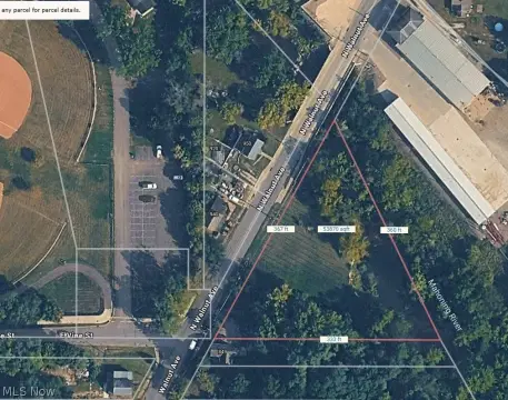
This exceptional 0.71-acre commercial and residential land parcel, located at 835 W State St in Alliance, Ohio (zip code 44601), presents a unique build-to-suit opportunity. The property boasts a generous 30,927 square feet and a significant 180-foot frontage, offering excellent visibility and accessibility. Zoned B-2, it benefits from all available utilities and multiple points of ingress/egress for safe and convenient access. The site enjoys direct access to four city streets and a traffic signal, enhancing its strategic location. Situated in the Canton submarket of the Cleveland cluster, this land parcel is strategically positioned within a high-population-density area, both within a 2-mile and 15-mile radius. Its location along a major roadway further enhances its appeal. The property's proximity to Mount Union University, including its student housing, athletic facilities, and sports venues, provides a strong potential customer base. A detailed site information attachment is available upon request. The property is offered with a $40,000 annual ground lease.
Value Estimations
based on Realmo’s proprietary methodology
-
AI approach
-
CAP approach
-
Comparable approach
-
Alternative Use
Get a detailed, property-specific estimation — fast and free
Location Insight
- Map
- Local Demand
- City
- Alliance
- County
- Stark
- State
- Ohio
- Longitude
- -81.1163
- Latitude
- 40.9021
- CBSA code
- 15940
- CBSA name
- CANTON-MASSILLON, OH METROPOLITAN STATISTICAL AREA
Property Tax & Assessments
Tax date
Tax Amount
Assessed Land Value
Assessed Improvement Value
Total Assessed Value
Applied Tax Rate
Land Market Value
Improvement Market Value
Total Market Value
2023
$5,233
$98,740
$0.00
$98,740
-
$282,100
$0.00
$282,100