7131-7161 Co 97th Rd Mount Gilead, OH 43338
Property profile & analytics
7131-7161 Co 97th Rd, Mount Gilead, OH 43338
- Apartment buildings
- 1,808 SF
- 3.16 lot acres
Property ID
US66-1550349
The Realmo ID is a unique identifier assigned to every property, incorporating country codes and precise geo-coordinates for 300x300-foot land blocks. It enables standardized data collection and seamless integration of disparate sources such as ownership, tax, title data and physical specifications. By aggregating current and historical records, the Realmo ID powers advanced analytics and delivers deep, verifiable insights for real estate professionals.
Location Intelligence
Current Use by Public Records
- Apartment buildings
Property Details for 7131-7161 Co 97th Rd
- Year built
- 1978
- Lot size
- 3.16 lot acres
- Property type
- Apartment buildings
- APN
- L32-001-00-297-03
- APU
- L320010029703
Sales History
| Date | Price | Buyer | Seller | Deed Type | Mortgage |
|---|---|---|---|---|---|
| Aug 14, 2020 | $608,000 | Knj Investments | Dr&ll Welch Ft | Deed | — |
Value Estimations
based on Realmo’s proprietary methodology
-
AI approach
- Method
- Estimation
- Statistic approach
- $515,000
- ML approach
- $640,000
Get a detailed, property-specific estimation — fast and free
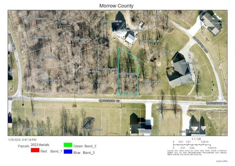
Location Insight
- Map
- Local Demand
- City
- Mount Gilead
- County
- Morrow
- State
- Ohio
- Longitude
- -82.6648
- Latitude
- 40.6016
- CBSA code
- 18140
- CBSA name
- COLUMBUS, OH METROPOLITAN STATISTICAL AREA
Property Tax & Assessments
Tax date
Tax Amount
Assessed Land Value
Assessed Improvement Value
Total Assessed Value
Applied Tax Rate
Land Market Value
Improvement Market Value
Total Market Value
2023
$9,608
$33,640
$167,930
$201,570
-
$96,100
$479,800
$575,900