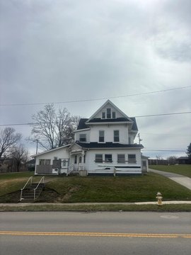
669 Barnard Ave Mansfield, OH 44903-1827
Property profile & analytics
669 Barnard Ave, Mansfield, OH 44903-1827
- Residential income homes
- 5,760 SF
- 0.23 lot acres
Property ID
US66-1417644
The Realmo ID is a unique identifier assigned to every property, incorporating country codes and precise geo-coordinates for 300x300-foot land blocks. It enables standardized data collection and seamless integration of disparate sources such as ownership, tax, title data and physical specifications. By aggregating current and historical records, the Realmo ID powers advanced analytics and delivers deep, verifiable insights for real estate professionals.
Location Intelligence
Current Use by Public Records
- Residential income homes
Property Details for 669 Barnard Ave
- Year built
- 1950
- Lot size
- 0.23 lot acres
- Property type
- Residential income homes
- Property subtype
- Small apartment buildings
- APN
- 027-02-078-14-000
- APU
- 270207814000
Sales History
| Date | Price | Buyer | Seller | Deed Type | Mortgage |
|---|---|---|---|---|---|
| Feb 21, 2012 | — | Carl Schroeder | C & C Schroeder Ltd | Quit Claim Deed · related | — |
| Nov 9, 2011 | — | Carl E Schroeder | Cynthia A Roush | Intrafamily Transfer · related | — |
| Mar 17, 2011 | — | Carl E Schroeder | C & C Schroeder Ltd | Quit Claim Deed · related | — |
Value Estimations
based on Realmo’s proprietary methodology
-
AI approach
-
CAP approach
-
Comparable approach
-
Alternative Use
Get a detailed, property-specific estimation — fast and free
Location Insight
- Map
- Local Demand
- City
- Mansfield
- County
- Richland
- State
- Ohio
- Longitude
- -82.5407
- Latitude
- 40.7496
- CBSA code
- 31900
- CBSA name
- MANSFIELD, OH METROPOLITAN STATISTICAL AREA
Property Tax & Assessments
Tax date
Tax Amount
Assessed Land Value
Assessed Improvement Value
Total Assessed Value
Applied Tax Rate
Land Market Value
Improvement Market Value
Total Market Value
2023
$2,945
$5,600
$36,010
$41,610
-
$16,000
$102,880
$118,880