6673 State 371st NW Walker, MN 56484
Property profile & analytics
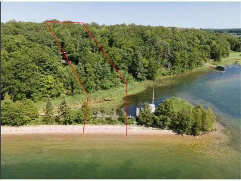
6673 State 371st NW, Walker, MN 56484
- Commercial real estate
- 8.27 lot acres
Property ID
US46-1192133
The Realmo ID is a unique identifier assigned to every property, incorporating country codes and precise geo-coordinates for 300x300-foot land blocks. It enables standardized data collection and seamless integration of disparate sources such as ownership, tax, title data and physical specifications. By aggregating current and historical records, the Realmo ID powers advanced analytics and delivers deep, verifiable insights for real estate professionals.
Location Intelligence
Current Use by Public Records
- Commercial real estate
Property Details for 6673 State 371st NW
- Year built
- 1997
- Lot size
- 8.27 lot acres
- Property type
- Commercial real estate
- APN
- 38-012-1304
- APU
- 380121304
Sales History
| Date | Price | Buyer | Seller | Deed Type | Mortgage |
|---|---|---|---|---|---|
| Aug 15, 2023 | — | C Selman Enterprises INC | Kathy Jo Bieloh | Warranty Deed | — |
| Jul 18, 2017 | — | Kathy J Bieloh | — | Deed · related | $305k · First National Bank |
| Jul 15, 2016 | — | Kathy Jo Bieloh | — | Deed · related | $226k · First National Bank |
| Sep 19, 2011 | — | Kathy Jo Bieloh | William E Bieloh | Affidavit Of Death Of Joint Tenant · related | — |
Value Estimations
based on Realmo’s proprietary methodology
-
AI approach
-
CAP approach
-
Comparable approach
-
Alternative Use
Get a detailed, property-specific estimation — fast and free
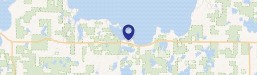
Location Insight
- Map
- Local Demand
- City
- Walker
- County
- Cass
- State
- Minnesota
- Longitude
- -94.5417
- Latitude
- 47.0472
- CBSA code
- 14660
- CBSA name
- BRAINERD, MN MICROPOLITAN STATISTICAL AREA
Property Tax & Assessments
Tax date
Tax Amount
Assessed Land Value
Assessed Improvement Value
Total Assessed Value
Applied Tax Rate
Land Market Value
Improvement Market Value
Total Market Value
2023
$824
$41,000
$14,000
$55,000
-
$41,000
$14,000
$55,000