
New search
Property profile & analytics
OFF-MARKET
Estimated value
$3,050,000
Industrial properties
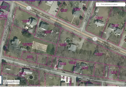
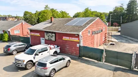
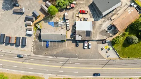
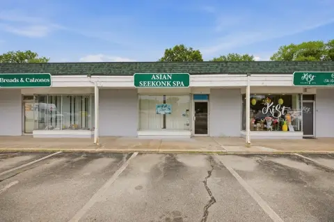
610 Gar Hwy, Swansea, MA 02777-4505
Individually Owned
4-yr Hold
~
Est. High Equity
Property ID
US38-0515431
Property profile
Verified
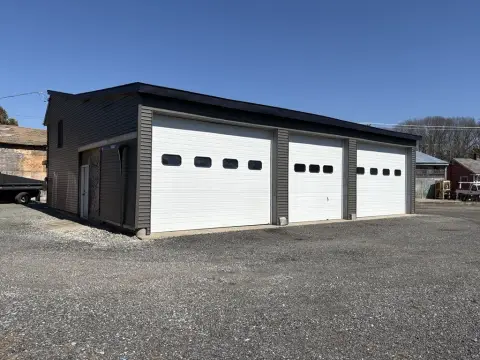
Property type
Industrial properties
Use group
MIXED USE (COMMERCIAL/INDUSTRIAL)
Year built
1989
Construction
STEEL FRAME
Total area
7,200 SF
Lot
2.91 ac (126,761 SF)
Zoning code
I
APN
SWAN M:074.0 B:0023 L:00000
UPID
US38-0515431
Cap rate & NOI
Priority signal for investors
Implied cap rate, NOI & suggested price
Cap rate vs submarket · NOI estimate · 3 price anchors
Implied cap rate, NOI & suggested price
Cap vs submarket · NOI estimate · 3 price anchors
Value estimations
Realmo proprietary · 4 methods
AI Approach
AI
by Request
CAP Approach
CAP
by Request
Comparable Approach
Comparable
by Request
Blend (final)
Blend
$3.05M
Owner & transaction history
610 Grand Army Republic · 4 yrs held
610 Grand Army Republic
since 2022
Last sale
$3.3M
7 recorded transactions
Zoning & alternative use
I · Swansea, MA
Permitted uses
Permitted uses
Allowed · conditional · prohibited
Cap rate
Implied · in-place · derived from last sale + estimated NOI
Implied Cap rate
#1
Implied · in-place · NOI ÷ last sale
In-place · derived from last sale + estimated NOI
Cap rate, NOI & submarket benchmark
Implied cap rate vs Swansea submarket · NOI estimate · Typical band, median & reading
Implied cap rate, NOI & submarket benchmark
Cap vs Swansea submarket · NOI estimate · typical band, median & reading
Refine your cap rate
8-question underwriting flow
1.
Property current status — Going-In vs Stabilized
2.
Price for denominator — asking / offer / market
3.
Leasing status & lease structure (NNN / Gross)
4.
Tenant risk profile & vacancy assumption
5.
Upload T12 / rent roll / OM (optional)
Refine in 60 seconds, get exact suggested price
T12 upload · Submarket benchmarks · Sensitivity grid
Suggested price · 3 cap rate anchors
Income approach @ 5% / 7% / 9% — aggressive / typical / conservative
Suggested price at 5% / 7% / 9% cap
Aggressive / typical / conservative · Implied $/SF per anchor · Sensitivity grid
Suggested price at 5% / 7% / 9% cap
Aggressive / typical / conservative · implied $/SF · sensitivity
Value
AI, CAP & Alternative Use estimations · Realmo proprietary blendValue Estimations
Based on Realmo’s proprietary methodology
AI Approach
CAP Approach
Comparable Approach
Alternative Use
Get a detailed, property-specific estimation — fast and free
Price per SF
Sale + rent benchmarks
Subject property
$424 / SF
Submarket sale & rent benchmarks
Median sale $/SF · Asking & closed rent · Submarket vacancy
Submarket sale & rent benchmarks
Median sale $/SF · asking & closed rent · submarket vacancy
Property tax & assessments
Tax year 2022Property tax & assessments
Tax year 2022
Tax billed
$27,216
Tax year 2022
Assessed value
$1,322,000
Assessed 2024
Previous assessed
$1,206,900
+9.5% YoY
Effective rate
2.06%
On assessed value
Assessed land
$613,000
Assessed improvement
$709,000
Comparables
6 recent transactions · within 1.5 miComparable in this city
6 recent transactions
Comparable in this City


Similar Nearby for Sale


Similar Nearby for Lease
Recent comparable sales
Sale price & price/SF · Sale date & distance · Adjustments & confidence
Recent comparable sales
Sale price & $/SF · sale date & distance · adjustments
Property description
Physical attributes from public recordsBuilding & lot
Public records
Property type
Industrial properties
Use group
MIXED USE (COMMERCIAL/INDUSTRIAL)
Status
Off-Market
Year built
1989
Construction
STEEL FRAME
Heating
FORCED AIR
Cooling
YES
Buildings
1
Stories
1
Units
1
Total area
7,200 SF
Lot
2.91 ac (126,761 SF)
Zoning code
I
APN
SWAN M:074.0 B:0023 L:00000
UPID
US38-0515431
Jurisdiction
SWANSEA
Zoning & alternative use
I · Swansea, MA
Zoning I · permitted uses
I · Swansea, MA
Permitted & conditional uses
Allowed uses · Special-permit conditions · Prohibited uses
Permitted & conditional uses
Allowed · special-permit conditions · prohibited
Swansea. Always verify with local authorities before improvements.
Building & site characteristics
From public records
Year built
1989
Construction
STEEL FRAME
Heating
FORCED AIR
Cooling
Yes
Stories
1
Buildings
1
Units
1
Lot
2.91 ac
Current owner
From public records · entity-resolved
610 Grand Army Republic
Individual
Mailing address
610 GAR HWY, SWANSEA, MA 02777-4505
Ownership since
2022
Owner contacts — direct phone, email, and related entities
Decision-maker phone · Verified email · Related entities & filings
Owner contacts
Email · phone · related entities
Sales History
12 recorded events · public records
Date
Price
Buyer
Seller
Deed Type
Mortgage
May 13, 2022
$3,300,000
610 Grand Army Republic
Low Side RT
Quit Claim Arm's Length For Ne States
$2,550,000 · Rsc Irt
Apr 7, 2022
—
Roland G Levesque
Swansea Town Of
Redemption Deed
related
—
Jun 25, 2021
—
C Diamond Infra LLC
—
Deed
related
$665,000,000 · Deutsche Bank National Trust Co
Sep 29, 2014
—
Low,side Realty Trust
Raising Cain Realty Trust
Quit Claim Deed
related
—
Oct 28, 2011
$1
Unison Site Mgmt LLC
Raising Cain RT
Grant Deed
—
Apr 15, 2011
—
Raising Cain RT
—
Deed Of Trust
related
$80,000 · Terrence M Tyrell
Dec 30, 1999
—
Raising Cain RT
—
Deed Of Trust
related
$330,000 · Fall River Five Cents
Nov 26, 1997
—
Raising Cain RT
—
Deed Of Trust
related
$35,000 · Misc Other
Jul 29, 1996
—
Raising Cain RT
—
Deed Of Trust
related
$80,000 · Lois Madoff
Nov 21, 1995
—
Raising Cain RT
—
Deed Of Trust
related
$350,000 · Rockland Trust Co
Apr 22, 1994
—
Roland G Levesque
—
Deed Of Trust
related
$300,000 · J&l Financial Corp
—
—
Side Low
—
Deed Of Trust
related
$100,000 · St Anne's Cu
Coming soon
Costs & Benchmarks
Operating expenses, capex projections, utility benchmarks, and submarket comparables — all in one view.
Coming soon
Risks
Flood, climate, environmental, title, and tenant-concentration risk — surfaced with mitigations and source citations.
Try Rey
Ask anything about this address in plain English.
“Is 15.6% cap rate sustainable?” · “Best tenant mix for BU1?” · “What’s the redev upside?”
You own 610 Gar Hwy?
List it free. Reach 20,000 daily buyers.
We’ve already pulled the facts. Confirm photos + price and you’re live in 2 minutes.
List this address →
Full reports are paid
Unlock the full Property Analytics report
Start free for 7 days — no card required. Full owner contacts, all 4 valuations with methodology, refine flow, comparable adjustments, foot-traffic deep dive, export to PDF / CSV.


