573 Selma Rd Springfield, OH 45505
Property profile & analytics
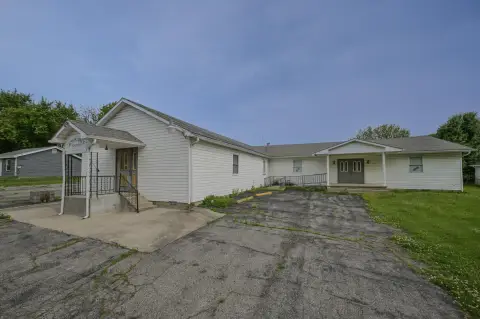
573 Selma Rd, Springfield, OH 45505
- Office Spaces
- 0.16 lot acres
Property ID
US66-0102928
The Realmo ID is a unique identifier assigned to every property, incorporating country codes and precise geo-coordinates for 300x300-foot land blocks. It enables standardized data collection and seamless integration of disparate sources such as ownership, tax, title data and physical specifications. By aggregating current and historical records, the Realmo ID powers advanced analytics and delivers deep, verifiable insights for real estate professionals.
Location Intelligence
Current Use by Public Records
- Office Spaces
Property Details for 573 Selma Rd
- Lot size
- 0.16 lot acres
- Property type
- Office Spaces
- APN
- 340-07-00034-407-067
- APU
- 3400700034407067
Sales History
| Date | Price | Buyer | Seller | Deed Type | Mortgage |
|---|---|---|---|---|---|
| Aug 10, 2018 | — | Central Fire Protection Co INC | — | Deed · related | $497k · Security National Bank |
| Dec 31, 2008 | $400,000 | Central Fire Protection Co INC | Gifford & Adkins Dev | Warranty Deed | — |
| Mar 9, 2004 | — | Gifford Development | Mundy,willetta G | Grant Deed · related | — |
| — | — | Central Fire Protection Co INC | — | Deed Of Trust · related | $300k · Huntington National Bank |
Value Estimations
based on Realmo’s proprietary methodology
-
AI approach
-
CAP approach
-
Comparable approach
-
Alternative Use
Get a detailed, property-specific estimation — fast and free
Location Insight
- Map
- Local Demand
- City
- Springfield
- County
- Clark
- State
- Ohio
- Longitude
- -83.8017
- Latitude
- 39.9144
- CBSA code
- 44220
- CBSA name
- SPRINGFIELD, OH METROPOLITAN STATISTICAL AREA
Property Tax & Assessments
Tax date
Tax Amount
Assessed Land Value
Assessed Improvement Value
Total Assessed Value
Applied Tax Rate
Land Market Value
Improvement Market Value
Total Market Value
2023
$562
$6,700
$1,050
$7,750
-
$19,140
$3,000
$22,140