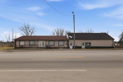
485 Ashland Rd Mansfield, OH 44905-2454
Property profile & analytics
485 Ashland Rd, Mansfield, OH 44905-2454
- Retail space
- 2,560 SF
- 0.48 lot acres
Property ID
US66-6079351
The Realmo ID is a unique identifier assigned to every property, incorporating country codes and precise geo-coordinates for 300x300-foot land blocks. It enables standardized data collection and seamless integration of disparate sources such as ownership, tax, title data and physical specifications. By aggregating current and historical records, the Realmo ID powers advanced analytics and delivers deep, verifiable insights for real estate professionals.
Location Intelligence
Current Use by Public Records
- Ministries of Hope And Healing, llc / Church / Mosque
Property Details for 485 Ashland Rd
- Year built
- 1945
- Construction
- FRAME
- Lot size
- 0.48 lot acres
- Property type
- Retail space
- APN
- 028-90-058-07-000
- APU
- 289005807000
Sales History
| Date | Price | Buyer | Seller | Deed Type | Mortgage |
|---|---|---|---|---|---|
| Mar 29, 2024 | — | Angela Rene Kerby | Clyde Kerby | Intrafamily Transfer · related | — |
Value Estimations
based on Realmo’s proprietary methodology
-
AI approach
-
CAP approach
-
Comparable approach
-
Alternative Use
Get a detailed, property-specific estimation — fast and free
Location Insight
- Map
- Local Demand
- City
- Mansfield
- County
- Richland
- State
- Ohio
- Longitude
- -82.491
- Latitude
- 40.7649
- CBSA code
- 31900
- CBSA name
- MANSFIELD, OH METROPOLITAN STATISTICAL AREA
Property Tax & Assessments
Tax date
Tax Amount
Assessed Land Value
Assessed Improvement Value
Total Assessed Value
Applied Tax Rate
Land Market Value
Improvement Market Value
Total Market Value
2023
$1,358
$8,690
$8,810
$17,500
-
$24,830
$25,170
$50,000