
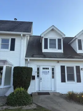
450 State Rd Dartmouth, MA 02747-4323
Property profile & analytics
450 State Rd, Dartmouth, MA 02747-4323
- Retail space
- 3,927 SF
- 1.18 lot acres
Property ID
US38-0707852
The Realmo ID is a unique identifier assigned to every property, incorporating country codes and precise geo-coordinates for 300x300-foot land blocks. It enables standardized data collection and seamless integration of disparate sources such as ownership, tax, title data and physical specifications. By aggregating current and historical records, the Realmo ID powers advanced analytics and delivers deep, verifiable insights for real estate professionals.
Location Intelligence
Current Use by Public Records
- AT&T Store / Mobile Phone Store / Electronics & Wireless Store
- Dunkin' / Bakery / Specialty Food Shop
Property Details for 450 State Rd
- Year built
- 2007
- Construction
- MASONRY/CONCRETE MASONRY UNITS (CMUS)
- Lot size
- 1.18 lot acres
- Zone code
- GB
- Property type
- Retail space
- APN
- DART M:0166 B:0141 L:0000
- APU
- DARTM0166B0141L0000
Sales History
| Date | Price | Buyer | Seller | Deed Type | Mortgage |
|---|---|---|---|---|---|
| Sep 2, 2005 | $625,000 | Michael Panagakos | Esther M Martin | Deed | $650k · Slades Ferry Tr Co |
| Sep 2, 2005 | $1 | Esther M Martin | Jardin Antone S Est | Grant Deed · related | — |
| Sep 23, 1991 | — | Ester Martin | — | Deed Of Trust · related | $16k · Citizens Bank Of Ma |
Value Estimations
based on Realmo’s proprietary methodology
-
CAP approach
- CAP Return
- Estimation
- 6%
- $1,345,000
- 6.5%
- $1,240,000
- 7%
- $1,150,000
-
Comparable approach
- Method
- Estimation
- Statistic Estimate
- $1,061,000
- AI Estimate
- $942,000
Market price range: $312k - $1.06MMarket price range: $299k - $943k -
Alternative Use
- Use
- Estimation
- AUTO REPAIR, GARAGE
- $700,000
Get a detailed, property-specific estimation — fast and free
Location Insight
- Map
- Local Demand
- City
- Dartmouth
- County
- Bristol
- State
- Massachusetts
- Longitude
- -71.0014
- Latitude
- 41.6409
- CBSA code
- 39300
- CBSA name
- PROVIDENCE-NEW BEDFORD-FALL RIVER, RI-MA METROPOLITAN STATISTICAL AREA
Property Tax & Assessments
Tax date
Tax Amount
Assessed Land Value
Assessed Improvement Value
Total Assessed Value
Applied Tax Rate
Land Market Value
Improvement Market Value
Total Market Value
2024
$19,732
$756,200
$302,400
$1,058,600
-
$0.00
$0.00
$0.00
Comparable in this City


Similar Nearby for Lease

Property Visit Statistics
-
Visits by month10.8k
-
Visitors by month6.3k
-
Avg Time on site8 min


