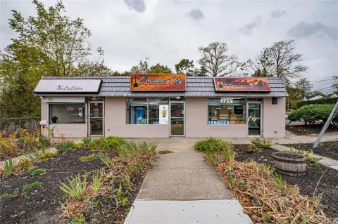
394 Mooney Pond Rd Farmingville, NY 11738-1436
Property profile & analytics
394 Mooney Pond Rd, Farmingville, NY 11738-1436
- Investment properties
- 0.28 lot acres
Property ID
US63-0139761
The Realmo ID is a unique identifier assigned to every property, incorporating country codes and precise geo-coordinates for 300x300-foot land blocks. It enables standardized data collection and seamless integration of disparate sources such as ownership, tax, title data and physical specifications. By aggregating current and historical records, the Realmo ID powers advanced analytics and delivers deep, verifiable insights for real estate professionals.
Location Intelligence
Current Use by Public Records
- Snetiker Arnold DDS / Dental Office
Property Details for 394 Mooney Pond Rd
- Lot size
- 0.28 lot acres
- Property type
- Investment properties
- Property subtype
- Live-work space
- APN
- 0200-538.00-04.00-029.000
- APU
- 200538000400029000
Sales History
| Date | Price | Buyer | Seller | Deed Type | Mortgage |
|---|---|---|---|---|---|
| Dec 5, 2018 | $320,000 | David Cooke | Snetiker,arnold & Linda | Grant Deed | — |
| Jun 7, 2012 | — | Arnold Snetiker | County Of Suffolk | Quit Claim Deed · related | — |
| Dec 1, 2011 | $11,398 | County Of Suffolk | Treasurer Of Suffolk County | Tax Deed · related | — |
Value Estimations
based on Realmo’s proprietary methodology
-
AI approach
-
CAP approach
-
Comparable approach
-
Alternative Use
Get a detailed, property-specific estimation — fast and free
Location Insight
- Map
- Local Demand
- City
- Farmingville
- County
- Suffolk
- State
- New York
- Longitude
- -73.0452
- Latitude
- 40.8509
- CBSA code
- 35620
- CBSA name
- NEW YORK-NORTHERN NEW JERSEY-LONG ISLAND, NY-NJ-PA METROPOLITAN STATISTICAL AREA
Property Tax & Assessments
Tax date
Tax Amount
Assessed Land Value
Assessed Improvement Value
Total Assessed Value
Applied Tax Rate
Land Market Value
Improvement Market Value
Total Market Value
2020
$0.00
$350
$3,025
$3,375
-
$648
$5,602
$6,250