
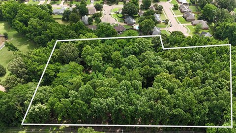
3889 New Brownsville Rd, Memphis, TN 38135
This exceptional 27.7-acre development site in Memphis, Tennessee, presents a unique investment opportunity. Located at 3889 New Brownsville Rd, Shelby County, zip code 38135, this property boasts approximately 1,600 feet of frontage along New Brownsville Road, situated about one mile south of its intersection with Austin Peay Highway (TN-14). The land is heavily wooded with a mix of pine and hardwood trees. The property is offered as a whole for $467,000, or can be divided into two parcels. The southern 14.3 acres are available for $250,000 and are zoned R-3. The northern 13.3 acres are priced at $217,000 and are zoned R-10. This fee simple ownership offers flexibility for various residential development projects, taking advantage of the distinct zoning designations in each parcel. The property's location and size make it ideal for a range of residential development plans. This is a rare opportunity to acquire a substantial land parcel in a desirable Memphis location. The latitude and longitude coordinates are 35.2331459654559 and -89.87994523085793 respectively.
Cap rate
Implied · in-place · derived from last sale + estimated NOIValue
AI, CAP & Alternative Use estimations · Realmo proprietary blendComparables
4 recent transactions · within 1.5 miComparable in this City


Similar Nearby for Sale
Property description
Physical attributes from public recordsZoning & alternative use
No recorded transactions found for this property.
Costs & Benchmarks
Operating expenses, capex projections, utility benchmarks, and submarket comparables — all in one view.
Risks
Flood, climate, environmental, title, and tenant-concentration risk — surfaced with mitigations and source citations.


