3616 N Sheridan Rd Peoria, IL 61606
Property profile & analytics
3616 N Sheridan Rd Peoria, IL 61606
- Commercial real estate

Property ID
US28-2008032
The Realmo ID is a unique identifier assigned to every property, incorporating country codes and precise geo-coordinates for 300x300-foot land blocks. It enables standardized data collection and seamless integration of disparate sources such as ownership, tax, title data and physical specifications. By aggregating current and historical records, the Realmo ID powers advanced analytics and delivers deep, verifiable insights for real estate professionals.
Location Intelligence
Current Use by Public Records
- Commercial real estate
Property Details for 3616 N Sheridan Rd
- Property type
- Commercial real estate
- APN
- 14-28-301-004
- APU
- 1428301004
Description
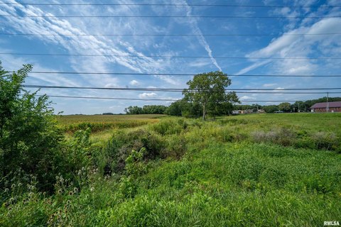
Exceptional redevelopment opportunity awaits with this 3.37-acre commercial land parcel located at 3616 N Sheridan Rd, Peoria, IL 61614. The property, zoned R-3, boasts excellent visibility from War Memorial Drive, a major thoroughfare with a daily traffic count of 25,000 vehicles. Previously occupied by a church, the site features a large existing asphalt parking lot, simplifying development plans. All utilities are readily available on-site, and the flat terrain ensures ease of construction. This strategically located land offers significant potential for a variety of commercial ventures, capitalizing on its high traffic count and convenient access. The asking price is $399,000. Detailed site plans and zoning information are available upon request. Don't miss this chance to acquire a prime piece of Peoria real estate with significant upside potential. The property is situated in Peoria County and offers a unique opportunity for investors and developers seeking a high-visibility location with existing infrastructure.
Value Estimations
based on Realmo’s proprietary methodology
-
AI approach
-
CAP approach
-
Comparable approach
-
Alternative Use
Get a detailed, property-specific estimation — fast and free
Location Insight
- Map
- Local Demand
- City
- Peoria
- County
- Peoria
- State
- Illinois
- Longitude
- -89.6021
- Latitude
- 40.7314
- CBSA code
- 37900
- CBSA name
- PEORIA, IL METROPOLITAN STATISTICAL AREA
Property Tax & Assessments
Tax date
Tax Amount
Assessed Land Value
Assessed Improvement Value
Total Assessed Value
Applied Tax Rate
Land Market Value
Improvement Market Value
Total Market Value
2023
$6,060
$64,410
$0.00
$64,410
-
$193,230
$0.00
$193,230