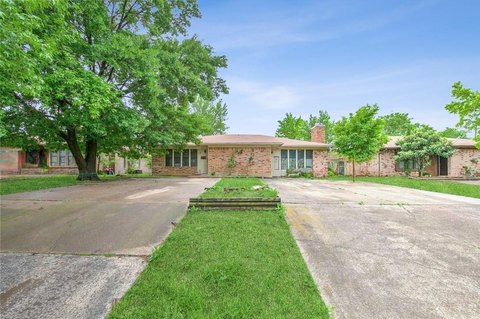
312 Watson Rd Arlington, TX 76010-2383
Property profile & analytics
312 Watson Rd, Arlington, TX 76010-2383
- Grocery and convenience stores
- 2,400 SF
- 0.63 lot acres
Property ID
US82-3851930
The Realmo ID is a unique identifier assigned to every property, incorporating country codes and precise geo-coordinates for 300x300-foot land blocks. It enables standardized data collection and seamless integration of disparate sources such as ownership, tax, title data and physical specifications. By aggregating current and historical records, the Realmo ID powers advanced analytics and delivers deep, verifiable insights for real estate professionals.
Location Intelligence
Current Use by Public Records
- Visa ATM / Atm
- #1 Food Store / Department Store
- Lupita's coquetas taqueria / Restaurant
Property Details for 312 Watson Rd
- Year built
- 1970
- Lot size
- 0.63 lot acres
- Property type
- Grocery and convenience stores
- APN
- 18820-17B-A
- APU
- 1882017BA
Sales History
| Date | Price | Buyer | Seller | Deed Type | Mortgage |
|---|---|---|---|---|---|
| Jan 22, 2016 | — | F & M Properties INC | Elegant Investment Group INC | Warranty Deed | — |
| Jan 15, 2016 | — | Ams Family Properties INC | F & M Properties INC | Grant Deed | — |
| Dec 11, 2015 | — | Elegant Investment Group INC | F & M Properties INC | Grant Deed | — |
Value Estimations
based on Realmo’s proprietary methodology
-
AI approach
-
CAP approach
-
Comparable approach
-
Alternative Use
Get a detailed, property-specific estimation — fast and free
Location Insight
- Map
- Local Demand
- City
- Arlington
- County
- Tarrant
- State
- Texas
- Longitude
- -97.0633
- Latitude
- 32.7327
- CBSA code
- 19100
- CBSA name
- DALLAS-FORT WORTH-ARLINGTON, TX METROPOLITAN STATISTICAL AREA
Property Tax & Assessments
Tax date
Tax Amount
Assessed Land Value
Assessed Improvement Value
Total Assessed Value
Applied Tax Rate
Land Market Value
Improvement Market Value
Total Market Value
2023
$6,068
$118,100
$176,900
$295,000
-
$118,100
$176,900
$295,000